You are here: Home > Network List > GE - GEOFON Stations List
> Station TRTE GEOFON Station Tartu, Estonia > Earthquake Result Viewer
TRTE GEOFON Station Tartu, Estonia - Earthquake Result Viewer
| Earthquake location: |
Pakistan |
| Earthquake latitude/longitude: |
30.0/68.2 |
| Earthquake time(UTC): |
1997/02/27 (058) 21:08:02 GMT |
| Earthquake Depth: |
33 km |
| Earthquake Magnitude: |
6.3 MB, 7.3 MS, 7.1 UNKNOWN, 6.6 ME |
| Earthquake Catalog/Contributor: |
WHDF/NEIC |
|
| Network: |
GE GEOFON |
| Station: |
TRTE GEOFON Station Tartu, Estonia |
| Lat/Lon: |
58.38 N/26.72 E |
| Elevation: |
0.0 m |
|
| Distance: |
40.1 deg |
| Az: |
327.186 deg |
| Baz: |
116.815 deg |
| Ray Param: |
0.07452812 |
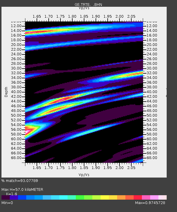
| Estimated Moho Depth: |
57.0 km |
| Estimated Crust Vp/Vs: |
1.60 |
| Assumed Crust Vp: |
6.552 km/s |
| Estimated Crust Vs: |
4.095 km/s |
| Estimated Crust Poisson's Ratio: |
0.18 |
|
| Radial Match: |
93.07789 % |
| Radial Bump: |
400 |
| Transverse Match: |
73.07573 % |
| Transverse Bump: |
400 |
| SOD ConfigId: |
4480 |
| Insert Time: |
2010-03-09 05:33:39.731 +0000 |
| GWidth: |
2.5 |
| Max Bumps: |
400 |
| Tol: |
0.001 |
|

Signal To Noise
| Channel | StoN | STA | LTA |
| GE:TRTE: :BHN:19970227T21:15:04.263989Z | 6.8366814 | 4.0243667E-6 | 5.8864333E-7 |
| GE:TRTE: :BHE:19970227T21:15:04.263989Z | 1.5952609 | 1.4855669E-6 | 9.3123765E-7 |
| GE:TRTE: :BHZ:19970227T21:15:04.263989Z | 1.8704222 | 2.5845247E-6 | 1.3817868E-6 |
| Arrivals |
| Ps | 5.7 SECOND |
| PpPs | 21 SECOND |
| PsPs/PpSs | 27 SECOND |


