You are here: Home > Network List > TA - USArray Transportable Network (new EarthScope stations) Stations List
> Station I30M Mount Dempster, Yukon, CAN > Earthquake Result Viewer
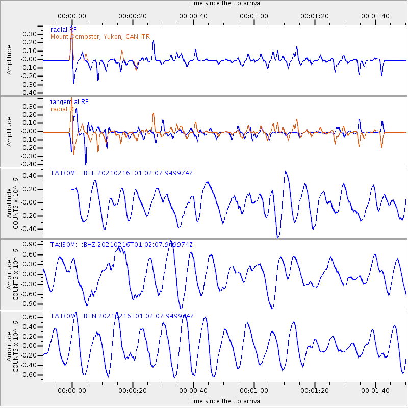
I30M Mount Dempster, Yukon, CAN - Earthquake Result Viewer
*The percent match for this event was below the threshold and hence no stack was calculated.
| Earthquake location: |
Vanuatu Islands |
| Earthquake latitude/longitude: |
-17.8/167.5 |
| Earthquake time(UTC): |
2021/02/16 (047) 00:49:26 GMT |
| Earthquake Depth: |
10 km |
| Earthquake Magnitude: |
6.2 Mww |
| Earthquake Catalog/Contributor: |
NEIC PDE/us |
|
| Network: |
TA USArray Transportable Network (new EarthScope stations) |
| Station: |
I30M Mount Dempster, Yukon, CAN |
| Lat/Lon: |
65.22 N/136.38 W |
| Elevation: |
1399 m |
|
| Distance: |
93.0 deg |
| Az: |
20.517 deg |
| Baz: |
232.403 deg |
| Ray Param: |
$rayparam |
*The percent match for this event was below the threshold and hence was not used in the summary stack. |
|
| Radial Match: |
66.23695 % |
| Radial Bump: |
400 |
| Transverse Match: |
79.60299 % |
| Transverse Bump: |
335 |
| SOD ConfigId: |
23341671 |
| Insert Time: |
2021-03-02 02:07:41.969 +0000 |
| GWidth: |
2.5 |
| Max Bumps: |
400 |
| Tol: |
0.001 |
|
Signal To Noise
| Channel | StoN | STA | LTA |
| TA:I30M: :BHZ:20210216T01:02:07.949974Z | 2.0192525 | 4.4724325E-7 | 2.2148951E-7 |
| TA:I30M: :BHN:20210216T01:02:07.949974Z | 2.4897854 | 4.6058145E-7 | 1.8498841E-7 |
| TA:I30M: :BHE:20210216T01:02:07.949974Z | 0.68077403 | 1.2784685E-7 | 1.877963E-7 |
| Arrivals |
| Ps | |
| PpPs | |
| PsPs/PpSs | |


