You are here: Home > Network List > TA - USArray Transportable Network (new EarthScope stations) Stations List
> Station M17K Holitna River, AK, USA > Earthquake Result Viewer
M17K Holitna River, AK, USA - Earthquake Result Viewer
| Earthquake location: |
Vanuatu Islands |
| Earthquake latitude/longitude: |
-17.8/167.5 |
| Earthquake time(UTC): |
2021/02/16 (047) 00:49:26 GMT |
| Earthquake Depth: |
10 km |
| Earthquake Magnitude: |
6.2 Mww |
| Earthquake Catalog/Contributor: |
NEIC PDE/us |
|
| Network: |
TA USArray Transportable Network (new EarthScope stations) |
| Station: |
M17K Holitna River, AK, USA |
| Lat/Lon: |
61.40 N/157.44 W |
| Elevation: |
387 m |
|
| Distance: |
83.8 deg |
| Az: |
16.158 deg |
| Baz: |
213.434 deg |
| Ray Param: |
0.045956023 |
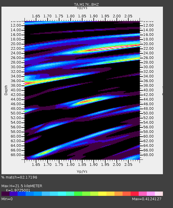
| Estimated Moho Depth: |
21.5 km |
| Estimated Crust Vp/Vs: |
1.97 |
| Assumed Crust Vp: |
6.155 km/s |
| Estimated Crust Vs: |
3.12 km/s |
| Estimated Crust Poisson's Ratio: |
0.33 |
|
| Radial Match: |
82.17196 % |
| Radial Bump: |
400 |
| Transverse Match: |
73.298164 % |
| Transverse Bump: |
400 |
| SOD ConfigId: |
23341671 |
| Insert Time: |
2021-03-02 02:07:58.660 +0000 |
| GWidth: |
2.5 |
| Max Bumps: |
400 |
| Tol: |
0.001 |
|

Signal To Noise
| Channel | StoN | STA | LTA |
| TA:M17K: :BHZ:20210216T01:01:23.925011Z | 8.160906 | 3.0980636E-6 | 3.796225E-7 |
| TA:M17K: :BHN:20210216T01:01:23.925011Z | 2.0861197 | 8.8128826E-7 | 4.2245335E-7 |
| TA:M17K: :BHE:20210216T01:01:23.925011Z | 1.338435 | 3.9727107E-7 | 2.968176E-7 |
| Arrivals |
| Ps | 3.5 SECOND |
| PpPs | 10 SECOND |
| PsPs/PpSs | 14 SECOND |


