You are here: Home > Network List > XW97 - Tien Shan Continental Dynamics Stations List
> Station BCHU XW.BCHU > Earthquake Result Viewer
BCHU XW.BCHU - Earthquake Result Viewer

| Earthquake location: |
Minahassa Peninsula, Sulawesi |
| Earthquake latitude/longitude: |
0.2/119.5 |
| Earthquake time(UTC): |
1999/02/23 (054) 07:27:56 GMT |
| Earthquake Depth: |
33 km |
| Earthquake Magnitude: |
5.6 MB, 5.8 MS |
| Earthquake Catalog/Contributor: |
WHDF/NEIC |
|
| Network: |
XW Tien Shan Continental Dynamics |
| Station: |
BCHU XW.BCHU |
| Lat/Lon: |
39.79 N/78.78 E |
| Elevation: |
1140 m |
|
| Distance: |
54.1 deg |
| Az: |
321.635 deg |
| Baz: |
126.335 deg |
| Ray Param: |
0.06557626 |
| Estimated Moho Depth: |
39.25 km |
| Estimated Crust Vp/Vs: |
1.97 |
| Assumed Crust Vp: |
6.242 km/s |
| Estimated Crust Vs: |
3.165 km/s |
| Estimated Crust Poisson's Ratio: |
0.33 |
|
| Radial Match: |
85.14099 % |
| Radial Bump: |
400 |
| Transverse Match: |
71.84817 % |
| Transverse Bump: |
400 |
| SOD ConfigId: |
4480 |
| Insert Time: |
2010-02-26 15:19:02.311 +0000 |
| GWidth: |
2.5 |
| Max Bumps: |
400 |
| Tol: |
0.001 |
|
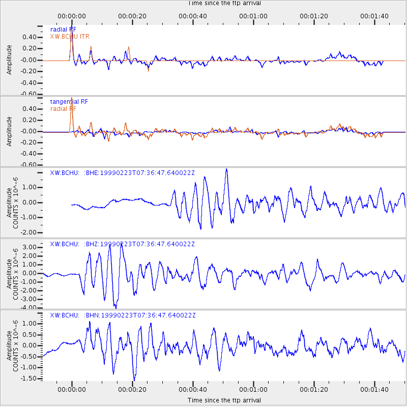
Signal To Noise
| Channel | StoN | STA | LTA |
| XW:BCHU: :BHZ:19990223T07:36:47.640022Z | 6.168219 | 8.119525E-7 | 1.3163483E-7 |
| XW:BCHU: :BHN:19990223T07:36:47.640022Z | 0.73198664 | 2.6302033E-7 | 3.5932396E-7 |
| XW:BCHU: :BHE:19990223T07:36:47.640022Z | 1.3046486 | 3.088438E-7 | 2.3672567E-7 |
| Arrivals |
| Ps | 6.4 SECOND |
| PpPs | 18 SECOND |
| PsPs/PpSs | 24 SECOND |


