You are here: Home > Network List > UU - University of Utah Regional Network Stations List
> Station FOR1 Milford Southwest, UT, USA > Earthquake Result Viewer
FOR1 Milford Southwest, UT, USA - Earthquake Result Viewer
| Earthquake location: |
Vanuatu Islands |
| Earthquake latitude/longitude: |
-17.8/167.5 |
| Earthquake time(UTC): |
2021/02/16 (047) 00:49:26 GMT |
| Earthquake Depth: |
10 km |
| Earthquake Magnitude: |
6.2 Mww |
| Earthquake Catalog/Contributor: |
NEIC PDE/us |
|
| Network: |
UU University of Utah Regional Network |
| Station: |
FOR1 Milford Southwest, UT, USA |
| Lat/Lon: |
38.37 N/113.09 W |
| Elevation: |
1642 m |
|
| Distance: |
92.9 deg |
| Az: |
50.69 deg |
| Baz: |
249.675 deg |
| Ray Param: |
0.04137433 |
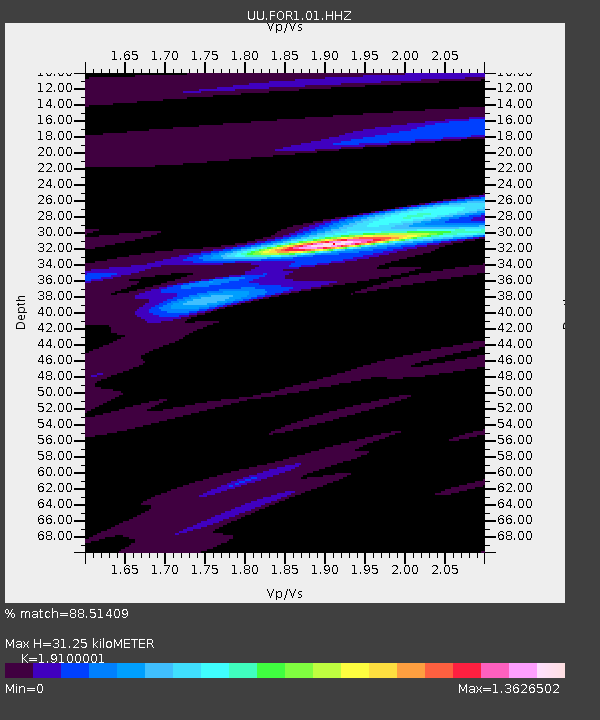
| Estimated Moho Depth: |
31.25 km |
| Estimated Crust Vp/Vs: |
1.91 |
| Assumed Crust Vp: |
6.276 km/s |
| Estimated Crust Vs: |
3.286 km/s |
| Estimated Crust Poisson's Ratio: |
0.31 |
|
| Radial Match: |
88.51409 % |
| Radial Bump: |
338 |
| Transverse Match: |
49.40331 % |
| Transverse Bump: |
353 |
| SOD ConfigId: |
23341671 |
| Insert Time: |
2021-03-02 02:10:25.119 +0000 |
| GWidth: |
2.5 |
| Max Bumps: |
400 |
| Tol: |
0.001 |
|

Signal To Noise
| Channel | StoN | STA | LTA |
| UU:FOR1:01:HHZ:20210216T01:02:07.560021Z | 6.802141 | 2.949517E-8 | 4.33616E-9 |
| UU:FOR1:01:HHN:20210216T01:02:07.560021Z | 1.78551 | 4.8692836E-9 | 2.727111E-9 |
| UU:FOR1:01:HHE:20210216T01:02:07.560021Z | 1.1906141 | 5.178082E-9 | 4.349085E-9 |
| Arrivals |
| Ps | 4.6 SECOND |
| PpPs | 14 SECOND |
| PsPs/PpSs | 19 SECOND |


