You are here: Home > Network List > GE - GEOFON Stations List
> Station TRTE GEOFON Station Tartu, Estonia > Earthquake Result Viewer
TRTE GEOFON Station Tartu, Estonia - Earthquake Result Viewer
| Earthquake location: |
South Indian Ocean |
| Earthquake latitude/longitude: |
-13.8/97.5 |
| Earthquake time(UTC): |
2000/06/18 (170) 14:44:13 GMT |
| Earthquake Depth: |
10 km |
| Earthquake Magnitude: |
6.8 MB, 7.8 MS, 7.8 MW, 7.6 MW |
| Earthquake Catalog/Contributor: |
WHDF/NEIC |
|
| Network: |
GE GEOFON |
| Station: |
TRTE GEOFON Station Tartu, Estonia |
| Lat/Lon: |
58.38 N/26.72 E |
| Elevation: |
0.0 m |
|
| Distance: |
91.9 deg |
| Az: |
330.158 deg |
| Baz: |
113.427 deg |
| Ray Param: |
0.0415446 |
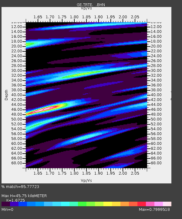
| Estimated Moho Depth: |
45.75 km |
| Estimated Crust Vp/Vs: |
1.67 |
| Assumed Crust Vp: |
6.552 km/s |
| Estimated Crust Vs: |
3.918 km/s |
| Estimated Crust Poisson's Ratio: |
0.22 |
|
| Radial Match: |
95.77723 % |
| Radial Bump: |
400 |
| Transverse Match: |
88.67409 % |
| Transverse Bump: |
400 |
| SOD ConfigId: |
3744 |
| Insert Time: |
2010-03-09 05:34:04.267 +0000 |
| GWidth: |
2.5 |
| Max Bumps: |
400 |
| Tol: |
0.001 |
|

Signal To Noise
| Channel | StoN | STA | LTA |
| GE:TRTE: :BHN:20000618T14:56:49.961001Z | 1.0673368 | 9.807306E-7 | 9.1885767E-7 |
| GE:TRTE: :BHE:20000618T14:56:49.961001Z | 2.0657284 | 1.5822982E-6 | 7.659759E-7 |
| GE:TRTE: :BHZ:20000618T14:56:49.961001Z | 5.717532 | 2.5279116E-6 | 4.4213337E-7 |
| Arrivals |
| Ps | 4.8 SECOND |
| PpPs | 18 SECOND |
| PsPs/PpSs | 23 SECOND |


