You are here: Home > Network List > GE - GEOFON Stations List
> Station TRTE GEOFON Station Tartu, Estonia > Earthquake Result Viewer
TRTE GEOFON Station Tartu, Estonia - Earthquake Result Viewer
| Earthquake location: |
Afghanistan-Tajikistan Bord Reg. |
| Earthquake latitude/longitude: |
36.4/71.5 |
| Earthquake time(UTC): |
2001/11/23 (327) 20:43:03 GMT |
| Earthquake Depth: |
106 km |
| Earthquake Magnitude: |
5.9 MB, 6.1 MW, 6.0 MW |
| Earthquake Catalog/Contributor: |
WHDF/NEIC |
|
| Network: |
GE GEOFON |
| Station: |
TRTE GEOFON Station Tartu, Estonia |
| Lat/Lon: |
58.38 N/26.72 E |
| Elevation: |
0.0 m |
|
| Distance: |
36.5 deg |
| Az: |
321.399 deg |
| Baz: |
107.16 deg |
| Ray Param: |
0.07629717 |
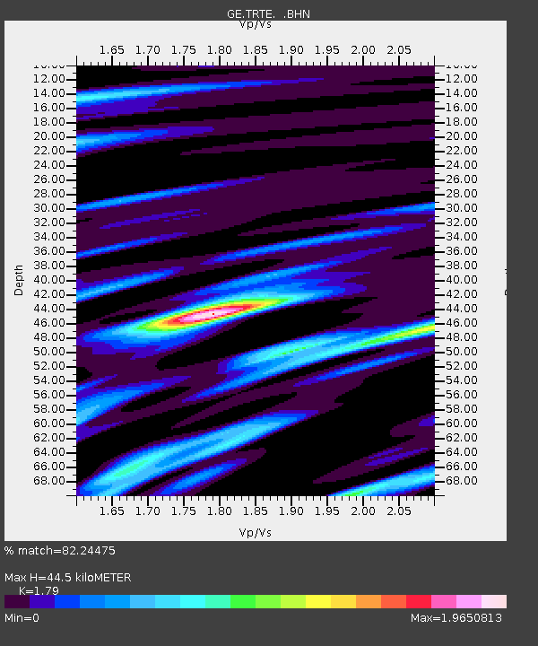
| Estimated Moho Depth: |
44.5 km |
| Estimated Crust Vp/Vs: |
1.79 |
| Assumed Crust Vp: |
6.552 km/s |
| Estimated Crust Vs: |
3.661 km/s |
| Estimated Crust Poisson's Ratio: |
0.27 |
|
| Radial Match: |
82.24475 % |
| Radial Bump: |
400 |
| Transverse Match: |
53.919117 % |
| Transverse Bump: |
400 |
| SOD ConfigId: |
20082 |
| Insert Time: |
2010-03-09 05:34:18.603 +0000 |
| GWidth: |
2.5 |
| Max Bumps: |
400 |
| Tol: |
0.001 |
|

Signal To Noise
| Channel | StoN | STA | LTA |
| GE:TRTE: :BHN:20011123T20:49:28.266003Z | 1.691357 | 1.3656204E-6 | 8.074111E-7 |
| GE:TRTE: :BHE:20011123T20:49:28.266003Z | 4.5800533 | 3.9942024E-6 | 8.720865E-7 |
| GE:TRTE: :BHZ:20011123T20:49:28.266003Z | 7.1351275 | 3.7919506E-6 | 5.3144817E-7 |
| Arrivals |
| Ps | 5.8 SECOND |
| PpPs | 18 SECOND |
| PsPs/PpSs | 23 SECOND |


