You are here: Home > Network List > GE - GEOFON Stations List
> Station TRTE GEOFON Station Tartu, Estonia > Earthquake Result Viewer
TRTE GEOFON Station Tartu, Estonia - Earthquake Result Viewer
| Earthquake location: |
Northern Molucca Sea |
| Earthquake latitude/longitude: |
1.3/126.2 |
| Earthquake time(UTC): |
2001/02/24 (055) 07:23:48 GMT |
| Earthquake Depth: |
35 km |
| Earthquake Magnitude: |
6.6 MB, 7.0 MS, 7.1 MW, 7.1 ME |
| Earthquake Catalog/Contributor: |
WHDF/NEIC |
|
| Network: |
GE GEOFON |
| Station: |
TRTE GEOFON Station Tartu, Estonia |
| Lat/Lon: |
58.38 N/26.72 E |
| Elevation: |
0.0 m |
|
| Distance: |
93.9 deg |
| Az: |
328.613 deg |
| Baz: |
81.221 deg |
| Ray Param: |
0.041148465 |
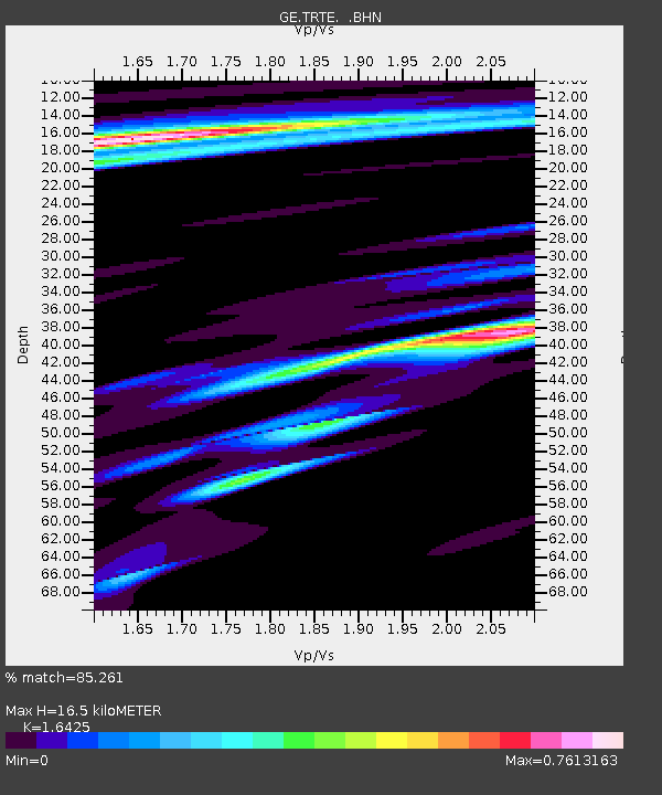
| Estimated Moho Depth: |
16.5 km |
| Estimated Crust Vp/Vs: |
1.64 |
| Assumed Crust Vp: |
6.552 km/s |
| Estimated Crust Vs: |
3.989 km/s |
| Estimated Crust Poisson's Ratio: |
0.21 |
|
| Radial Match: |
85.261 % |
| Radial Bump: |
400 |
| Transverse Match: |
55.97448 % |
| Transverse Bump: |
400 |
| SOD ConfigId: |
3744 |
| Insert Time: |
2010-03-09 05:34:24.656 +0000 |
| GWidth: |
2.5 |
| Max Bumps: |
400 |
| Tol: |
0.001 |
|

Signal To Noise
| Channel | StoN | STA | LTA |
| GE:TRTE: :BHN:20010224T07:36:31.464009Z | 1.1955421 | 1.2827027E-6 | 1.0729046E-6 |
| GE:TRTE: :BHE:20010224T07:36:31.464009Z | 1.648071 | 1.4877578E-6 | 9.0272675E-7 |
| GE:TRTE: :BHZ:20010224T07:36:31.464009Z | 4.95531 | 3.1201268E-6 | 6.296532E-7 |
| Arrivals |
| Ps | 1.7 SECOND |
| PpPs | 6.5 SECOND |
| PsPs/PpSs | 8.2 SECOND |


