You are here: Home > Network List > IU - Global Seismograph Network (GSN - IRIS/USGS) Stations List
> Station KMBO Kilima Mbogo, Kenya > Earthquake Result Viewer
KMBO Kilima Mbogo, Kenya - Earthquake Result Viewer

| Earthquake location: |
Bouvet Island Region |
| Earthquake latitude/longitude: |
-54.3/8.6 |
| Earthquake time(UTC): |
2017/10/10 (283) 18:53:28 GMT |
| Earthquake Depth: |
10 km |
| Earthquake Magnitude: |
6.7 mww |
| Earthquake Catalog/Contributor: |
NEIC PDE/us |
|
| Network: |
IU Global Seismograph Network (GSN - IRIS/USGS) |
| Station: |
KMBO Kilima Mbogo, Kenya |
| Lat/Lon: |
1.13 S/37.25 E |
| Elevation: |
1950 m |
|
| Distance: |
58.0 deg |
| Az: |
34.393 deg |
| Baz: |
199.345 deg |
| Ray Param: |
0.06315326 |
| Estimated Moho Depth: |
40.5 km |
| Estimated Crust Vp/Vs: |
1.75 |
| Assumed Crust Vp: |
6.601 km/s |
| Estimated Crust Vs: |
3.772 km/s |
| Estimated Crust Poisson's Ratio: |
0.26 |
|
| Radial Match: |
94.531166 % |
| Radial Bump: |
245 |
| Transverse Match: |
81.777596 % |
| Transverse Bump: |
400 |
| SOD ConfigId: |
2364251 |
| Insert Time: |
2017-10-24 18:54:28.583 +0000 |
| GWidth: |
2.5 |
| Max Bumps: |
400 |
| Tol: |
0.001 |
|
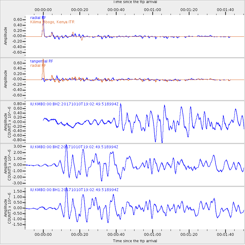
Signal To Noise
| Channel | StoN | STA | LTA |
| IU:KMBO:00:BHZ:20171010T19:02:49.518994Z | 2.615656 | 1.0066468E-7 | 3.8485442E-8 |
| IU:KMBO:00:BH1:20171010T19:02:49.518994Z | 1.4333192 | 8.673475E-8 | 6.0513216E-8 |
| IU:KMBO:00:BH2:20171010T19:02:49.518994Z | 0.59817004 | 6.579878E-8 | 1.1000012E-7 |
| Arrivals |
| Ps | 4.9 SECOND |
| PpPs | 16 SECOND |
| PsPs/PpSs | 21 SECOND |


