You are here: Home > Network List > AZ - ANZA Regional Network Stations List
> Station SMER AZ.SMER > Earthquake Result Viewer
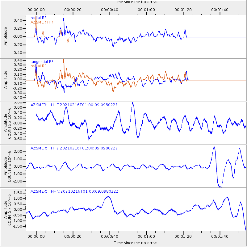
SMER AZ.SMER - Earthquake Result Viewer
*The percent match for this event was below the threshold and hence no stack was calculated.
| Earthquake location: |
Tonga Islands Region |
| Earthquake latitude/longitude: |
-17.8/-167.8 |
| Earthquake time(UTC): |
2021/02/16 (047) 00:49:28 GMT |
| Earthquake Depth: |
14 km |
| Earthquake Magnitude: |
6.7 Mi |
| Earthquake Catalog/Contributor: |
NEIC PDE/at |
|
| Network: |
AZ ANZA Regional Network |
| Station: |
SMER AZ.SMER |
| Lat/Lon: |
33.46 N/117.17 W |
| Elevation: |
355 m |
|
| Distance: |
70.2 deg |
| Az: |
43.378 deg |
| Baz: |
231.51 deg |
| Ray Param: |
$rayparam |
*The percent match for this event was below the threshold and hence was not used in the summary stack. |
|
| Radial Match: |
57.142323 % |
| Radial Bump: |
400 |
| Transverse Match: |
42.48829 % |
| Transverse Bump: |
400 |
| SOD ConfigId: |
23341671 |
| Insert Time: |
2021-03-02 02:16:43.453 +0000 |
| GWidth: |
2.5 |
| Max Bumps: |
400 |
| Tol: |
0.001 |
|
Signal To Noise
| Channel | StoN | STA | LTA |
| AZ:SMER: :HHZ:20210216T01:00:09.098022Z | 0.3681388 | 1.0954471E-7 | 2.9756362E-7 |
| AZ:SMER: :HHN:20210216T01:00:09.098022Z | 2.2147048 | 7.222747E-7 | 3.2612687E-7 |
| AZ:SMER: :HHE:20210216T01:00:09.098022Z | 2.2758982 | 4.5131912E-7 | 1.9830374E-7 |
| Arrivals |
| Ps | |
| PpPs | |
| PsPs/PpSs | |


