You are here: Home > Network List > IU - Global Seismograph Network (GSN - IRIS/USGS) Stations List
> Station PMSA Palmer Station, Antarctica > Earthquake Result Viewer
PMSA Palmer Station, Antarctica - Earthquake Result Viewer
| Earthquake location: |
Bouvet Island Region |
| Earthquake latitude/longitude: |
-54.3/8.6 |
| Earthquake time(UTC): |
2017/10/10 (283) 18:53:28 GMT |
| Earthquake Depth: |
10 km |
| Earthquake Magnitude: |
6.7 mww |
| Earthquake Catalog/Contributor: |
NEIC PDE/us |
|
| Network: |
IU Global Seismograph Network (GSN - IRIS/USGS) |
| Station: |
PMSA Palmer Station, Antarctica |
| Lat/Lon: |
64.77 S/64.05 W |
| Elevation: |
40 m |
|
| Distance: |
36.2 deg |
| Az: |
223.811 deg |
| Baz: |
108.7 deg |
| Ray Param: |
0.076796345 |
| Estimated Moho Depth: |
10.0 km |
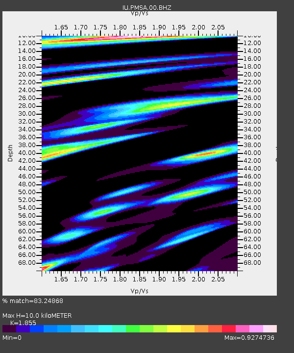
| Estimated Crust Vp/Vs: |
1.86 |
| Assumed Crust Vp: |
6.183 km/s |
| Estimated Crust Vs: |
3.333 km/s |
| Estimated Crust Poisson's Ratio: |
0.30 |
|
| Radial Match: |
83.24868 % |
| Radial Bump: |
400 |
| Transverse Match: |
65.27651 % |
| Transverse Bump: |
400 |
| SOD ConfigId: |
2364251 |
| Insert Time: |
2017-10-24 18:54:33.491 +0000 |
| GWidth: |
2.5 |
| Max Bumps: |
400 |
| Tol: |
0.001 |
|

Signal To Noise
| Channel | StoN | STA | LTA |
| IU:PMSA:00:BHZ:20171010T19:00:00.268994Z | 0.91551465 | 3.9573726E-7 | 4.3225663E-7 |
| IU:PMSA:00:BH1:20171010T19:00:00.268994Z | 1.6895171 | 6.8499395E-7 | 4.054377E-7 |
| IU:PMSA:00:BH2:20171010T19:00:00.268994Z | 1.2658306 | 3.6215707E-7 | 2.861023E-7 |
| Arrivals |
| Ps | 1.5 SECOND |
| PpPs | 4.3 SECOND |
| PsPs/PpSs | 5.8 SECOND |


