You are here: Home > Network List > GS - US Geological Survey Networks Stations List
> Station DEC09 Kile Street Surface Site > Earthquake Result Viewer
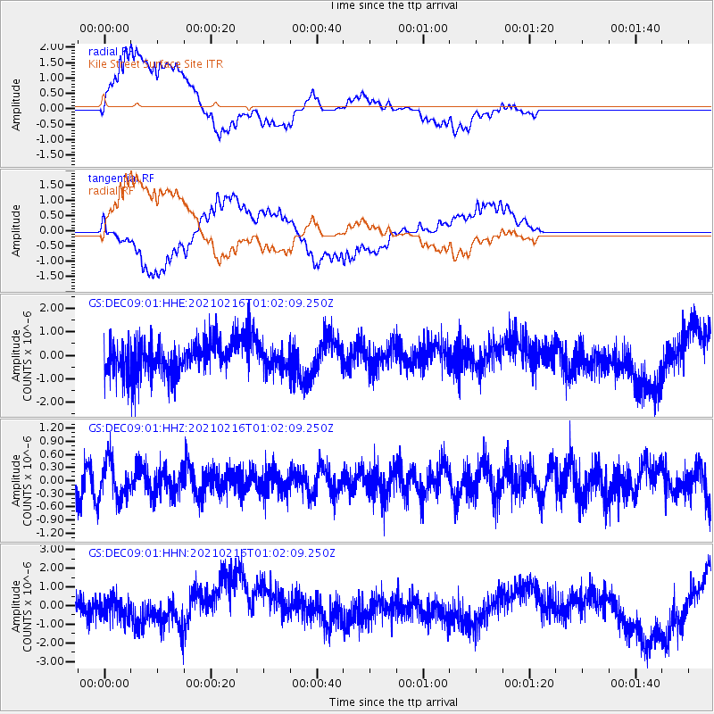
DEC09 Kile Street Surface Site - Earthquake Result Viewer
*The percent match for this event was below the threshold and hence no stack was calculated.
| Earthquake location: |
Tonga Islands Region |
| Earthquake latitude/longitude: |
-17.8/-167.8 |
| Earthquake time(UTC): |
2021/02/16 (047) 00:49:28 GMT |
| Earthquake Depth: |
14 km |
| Earthquake Magnitude: |
6.7 Mi |
| Earthquake Catalog/Contributor: |
NEIC PDE/at |
|
| Network: |
GS US Geological Survey Networks |
| Station: |
DEC09 Kile Street Surface Site |
| Lat/Lon: |
39.87 N/88.92 W |
| Elevation: |
207 m |
|
| Distance: |
93.0 deg |
| Az: |
49.126 deg |
| Baz: |
249.409 deg |
| Ray Param: |
$rayparam |
*The percent match for this event was below the threshold and hence was not used in the summary stack. |
|
| Radial Match: |
60.172794 % |
| Radial Bump: |
400 |
| Transverse Match: |
74.43681 % |
| Transverse Bump: |
400 |
| SOD ConfigId: |
23341671 |
| Insert Time: |
2021-03-02 02:21:29.097 +0000 |
| GWidth: |
2.5 |
| Max Bumps: |
400 |
| Tol: |
0.001 |
|
Signal To Noise
| Channel | StoN | STA | LTA |
| GS:DEC09:01:HHZ:20210216T01:02:09.250Z | 1.4178193 | 4.2876664E-7 | 3.0241276E-7 |
| GS:DEC09:01:HHN:20210216T01:02:09.250Z | 0.73637694 | 5.7762617E-7 | 7.8441644E-7 |
| GS:DEC09:01:HHE:20210216T01:02:09.250Z | 0.6365732 | 4.6210744E-7 | 7.259298E-7 |
| Arrivals |
| Ps | |
| PpPs | |
| PsPs/PpSs | |


