You are here: Home > Network List > GE - GEOFON Stations List
> Station TRTE GEOFON Station Tartu, Estonia > Earthquake Result Viewer
TRTE GEOFON Station Tartu, Estonia - Earthquake Result Viewer
| Earthquake location: |
Hindu Kush Region, Afghanistan |
| Earthquake latitude/longitude: |
36.5/70.5 |
| Earthquake time(UTC): |
2002/03/03 (062) 12:08:19 GMT |
| Earthquake Depth: |
226 km |
| Earthquake Magnitude: |
6.6 MB, 7.4 MW, 7.3 MW |
| Earthquake Catalog/Contributor: |
WHDF/NEIC |
|
| Network: |
GE GEOFON |
| Station: |
TRTE GEOFON Station Tartu, Estonia |
| Lat/Lon: |
58.38 N/26.72 E |
| Elevation: |
0.0 m |
|
| Distance: |
35.9 deg |
| Az: |
321.582 deg |
| Baz: |
108.139 deg |
| Ray Param: |
0.07612654 |
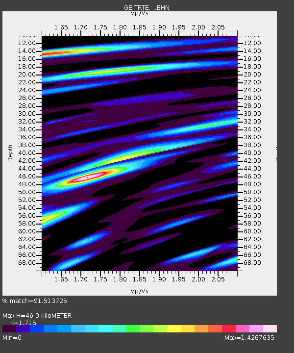
| Estimated Moho Depth: |
46.0 km |
| Estimated Crust Vp/Vs: |
1.72 |
| Assumed Crust Vp: |
6.552 km/s |
| Estimated Crust Vs: |
3.821 km/s |
| Estimated Crust Poisson's Ratio: |
0.24 |
|
| Radial Match: |
91.513725 % |
| Radial Bump: |
400 |
| Transverse Match: |
78.06273 % |
| Transverse Bump: |
400 |
| SOD ConfigId: |
20082 |
| Insert Time: |
2010-03-09 05:34:40.813 +0000 |
| GWidth: |
2.5 |
| Max Bumps: |
400 |
| Tol: |
0.001 |
|

Signal To Noise
| Channel | StoN | STA | LTA |
| GE:TRTE: :BHN:20020303T12:14:27.867014Z | 4.0039535 | 5.251998E-6 | 1.3117029E-6 |
| GE:TRTE: :BHE:20020303T12:14:27.867014Z | 9.408358 | 2.0254984E-5 | 2.1528713E-6 |
| GE:TRTE: :BHZ:20020303T12:14:27.867014Z | 11.342139 | 2.7304499E-5 | 2.40735E-6 |
| Arrivals |
| Ps | 5.4 SECOND |
| PpPs | 18 SECOND |
| PsPs/PpSs | 23 SECOND |


