You are here: Home > Network List > IU - Global Seismograph Network (GSN - IRIS/USGS) Stations List
> Station QSPA South Pole Remote Earth Science Observatory (Quiet Zone) > Earthquake Result Viewer
QSPA South Pole Remote Earth Science Observatory (Quiet Zone) - Earthquake Result Viewer
| Earthquake location: |
Tonga Islands Region |
| Earthquake latitude/longitude: |
-17.8/-167.8 |
| Earthquake time(UTC): |
2021/02/16 (047) 00:49:28 GMT |
| Earthquake Depth: |
14 km |
| Earthquake Magnitude: |
6.7 Mi |
| Earthquake Catalog/Contributor: |
NEIC PDE/at |
|
| Network: |
IU Global Seismograph Network (GSN - IRIS/USGS) |
| Station: |
QSPA South Pole Remote Earth Science Observatory (Quiet Zone) |
| Lat/Lon: |
89.93 S/144.44 E |
| Elevation: |
2850 m |
|
| Distance: |
72.3 deg |
| Az: |
180.056 deg |
| Baz: |
47.779 deg |
| Ray Param: |
0.053772617 |
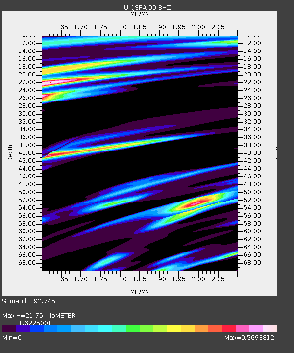
| Estimated Moho Depth: |
21.75 km |
| Estimated Crust Vp/Vs: |
1.62 |
| Assumed Crust Vp: |
6.193 km/s |
| Estimated Crust Vs: |
3.817 km/s |
| Estimated Crust Poisson's Ratio: |
0.19 |
|
| Radial Match: |
92.74511 % |
| Radial Bump: |
342 |
| Transverse Match: |
93.24113 % |
| Transverse Bump: |
323 |
| SOD ConfigId: |
23341671 |
| Insert Time: |
2021-03-02 02:22:19.965 +0000 |
| GWidth: |
2.5 |
| Max Bumps: |
400 |
| Tol: |
0.001 |
|

Signal To Noise
| Channel | StoN | STA | LTA |
| IU:QSPA:00:BHZ:20210216T01:00:21.468994Z | 10.431482 | 2.7660692E-6 | 2.6516548E-7 |
| IU:QSPA:00:BH1:20210216T01:00:21.468994Z | 2.4200256 | 7.5186244E-7 | 3.106837E-7 |
| IU:QSPA:00:BH2:20210216T01:00:21.468994Z | 1.6821375 | 6.347694E-7 | 3.7735882E-7 |
| Arrivals |
| Ps | 2.3 SECOND |
| PpPs | 8.9 SECOND |
| PsPs/PpSs | 11 SECOND |


