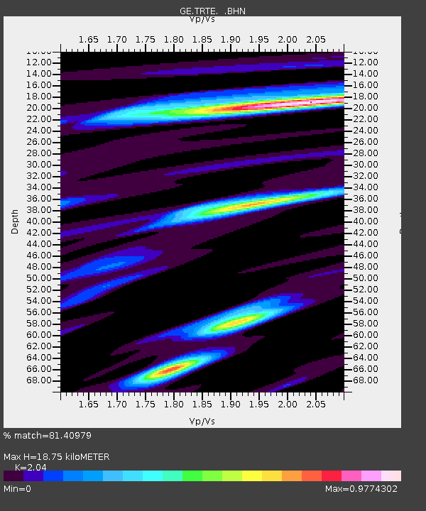
TRTE GEOFON Station Tartu, Estonia - Earthquake Result Viewer

Earthquake location: Near East Coast Of Kamchatka
Earthquake latitude/longitude: 54.7/162.9
Earthquake time(UTC): 1997/12/07 (341) 17:56:18 GMT
Earthquake Depth: 33 km
Earthquake Magnitude: 5.6 MB, 6.0 MS, 6.3 UNKNOWN, 6.1 MW
Earthquake Catalog/Contributor: WHDF/NEIC
Network: GE GEOFON
Station: TRTE GEOFON Station Tartu, Estonia
Lat/Lon: 58.38 N/26.72 E
Elevation: 0.0 m
Distance: 61.9 deg
Az: 335.565 deg
Baz: 27.142 deg
Ray Param: 0.060523838
Estimated Moho Depth: 18.75 km
Estimated Crust Vp/Vs: 2.04
Assumed Crust Vp: 6.552 km/s
Estimated Crust Vs: 3.212 km/s
Estimated Crust Poisson's Ratio: 0.34
Radial Match: 81.40979 %
Radial Bump: 400
Transverse Match: 57.410355 %
Transverse Bump: 400
SOD ConfigId: 4480
Insert Time: 2010-03-09 05:34:49.853 +0000
GWidth: 2.5
Max Bumps: 400
Tol: 0.001

Signal To Noise

ChannelStoNSTALTA
GE:TRTE: :BHN:19971207T18:06:04.166003Z3.42884092.6654054E-67.773488E-7
GE:TRTE: :BHE:19971207T18:06:04.166003Z2.00988961.8142604E-69.0266667E-7
GE:TRTE: :BHZ:19971207T18:06:04.166003Z1.40209641.0946222E-67.8070394E-7
Arrivals
Ps3.1 SECOND
PpPs8.4 SECOND
PsPs/PpSs11 SECOND