You are here: Home > Network List > TA - USArray Transportable Network (new EarthScope stations) Stations List
> Station E17K Hotham Inlet, AK, USA > Earthquake Result Viewer
E17K Hotham Inlet, AK, USA - Earthquake Result Viewer
| Earthquake location: |
Tonga Islands Region |
| Earthquake latitude/longitude: |
-17.8/-167.8 |
| Earthquake time(UTC): |
2021/02/16 (047) 00:49:28 GMT |
| Earthquake Depth: |
14 km |
| Earthquake Magnitude: |
6.7 Mi |
| Earthquake Catalog/Contributor: |
NEIC PDE/at |
|
| Network: |
TA USArray Transportable Network (new EarthScope stations) |
| Station: |
E17K Hotham Inlet, AK, USA |
| Lat/Lon: |
67.08 N/161.83 W |
| Elevation: |
233 m |
|
| Distance: |
84.7 deg |
| Az: |
2.346 deg |
| Baz: |
185.714 deg |
| Ray Param: |
0.045258574 |
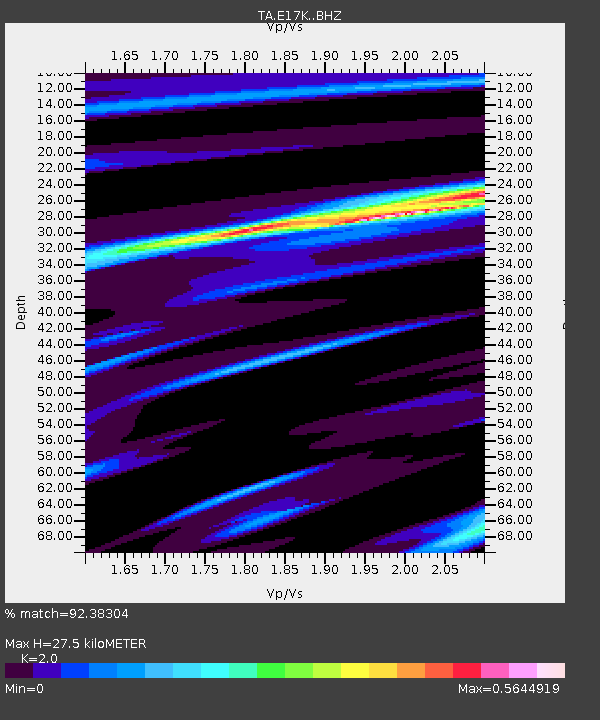
| Estimated Moho Depth: |
27.5 km |
| Estimated Crust Vp/Vs: |
2.00 |
| Assumed Crust Vp: |
6.276 km/s |
| Estimated Crust Vs: |
3.138 km/s |
| Estimated Crust Poisson's Ratio: |
0.33 |
|
| Radial Match: |
92.38304 % |
| Radial Bump: |
230 |
| Transverse Match: |
79.1139 % |
| Transverse Bump: |
399 |
| SOD ConfigId: |
23341671 |
| Insert Time: |
2021-03-02 02:27:21.189 +0000 |
| GWidth: |
2.5 |
| Max Bumps: |
400 |
| Tol: |
0.001 |
|

Signal To Noise
| Channel | StoN | STA | LTA |
| TA:E17K: :BHZ:20210216T01:01:30.075012Z | 1.8768042 | 2.5700794E-7 | 1.3693914E-7 |
| TA:E17K: :BHN:20210216T01:01:30.075012Z | 0.8273718 | 1.4274218E-7 | 1.7252484E-7 |
| TA:E17K: :BHE:20210216T01:01:30.075012Z | 1.2543991 | 1.5097419E-7 | 1.2035578E-7 |
| Arrivals |
| Ps | 4.5 SECOND |
| PpPs | 13 SECOND |
| PsPs/PpSs | 17 SECOND |


