You are here: Home > Network List > GE - GEOFON Stations List
> Station TRTE GEOFON Station Tartu, Estonia > Earthquake Result Viewer
TRTE GEOFON Station Tartu, Estonia - Earthquake Result Viewer
| Earthquake location: |
Southeast Of Taiwan |
| Earthquake latitude/longitude: |
22.3/125.3 |
| Earthquake time(UTC): |
1998/05/03 (123) 23:30:21 GMT |
| Earthquake Depth: |
33 km |
| Earthquake Magnitude: |
6.4 MB, 7.3 MS, 7.5 UNKNOWN, 7.5 ME |
| Earthquake Catalog/Contributor: |
WHDF/NEIC |
|
| Network: |
GE GEOFON |
| Station: |
TRTE GEOFON Station Tartu, Estonia |
| Lat/Lon: |
58.38 N/26.72 E |
| Elevation: |
0.0 m |
|
| Distance: |
75.6 deg |
| Az: |
327.47 deg |
| Baz: |
70.941 deg |
| Ray Param: |
0.051480554 |
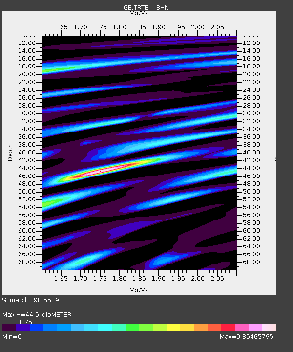
| Estimated Moho Depth: |
44.5 km |
| Estimated Crust Vp/Vs: |
1.75 |
| Assumed Crust Vp: |
6.552 km/s |
| Estimated Crust Vs: |
3.744 km/s |
| Estimated Crust Poisson's Ratio: |
0.26 |
|
| Radial Match: |
98.5519 % |
| Radial Bump: |
400 |
| Transverse Match: |
86.2288 % |
| Transverse Bump: |
400 |
| SOD ConfigId: |
4480 |
| Insert Time: |
2010-03-09 05:34:53.970 +0000 |
| GWidth: |
2.5 |
| Max Bumps: |
400 |
| Tol: |
0.001 |
|

Signal To Noise
| Channel | StoN | STA | LTA |
| GE:TRTE: :BHN:19980503T23:41:32.665015Z | 3.332859 | 9.720385E-7 | 2.9165304E-7 |
| GE:TRTE: :BHE:19980503T23:41:32.665015Z | 1.2880923 | 4.6098768E-7 | 3.5788406E-7 |
| GE:TRTE: :BHZ:19980503T23:41:32.665015Z | 2.5878854 | 7.5516573E-7 | 2.9180802E-7 |
| Arrivals |
| Ps | 5.3 SECOND |
| PpPs | 18 SECOND |
| PsPs/PpSs | 23 SECOND |


