You are here: Home > Network List > PQ - Public Safety Geoscience Program Canadian Research Network (PSGP) Stations List
> Station NAB2 Zama Lookout Tower, High Level Alberta > Earthquake Result Viewer
NAB2 Zama Lookout Tower, High Level Alberta - Earthquake Result Viewer
| Earthquake location: |
Vanuatu Islands |
| Earthquake latitude/longitude: |
-17.6/167.7 |
| Earthquake time(UTC): |
2021/02/16 (047) 01:22:19 GMT |
| Earthquake Depth: |
10 km |
| Earthquake Magnitude: |
5.5 mb |
| Earthquake Catalog/Contributor: |
NEIC PDE/us |
|
| Network: |
PQ Public Safety Geoscience Program Canadian Research Network (PSGP) |
| Station: |
NAB2 Zama Lookout Tower, High Level Alberta |
| Lat/Lon: |
58.60 N/119.17 W |
| Elevation: |
646 m |
|
| Distance: |
96.4 deg |
| Az: |
30.284 deg |
| Baz: |
246.68 deg |
| Ray Param: |
0.040521353 |
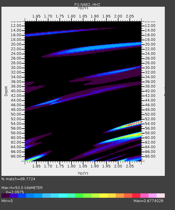
| Estimated Moho Depth: |
53.0 km |
| Estimated Crust Vp/Vs: |
2.10 |
| Assumed Crust Vp: |
6.444 km/s |
| Estimated Crust Vs: |
3.072 km/s |
| Estimated Crust Poisson's Ratio: |
0.35 |
|
| Radial Match: |
89.7724 % |
| Radial Bump: |
400 |
| Transverse Match: |
46.665 % |
| Transverse Bump: |
400 |
| SOD ConfigId: |
23341671 |
| Insert Time: |
2021-03-02 02:42:56.449 +0000 |
| GWidth: |
2.5 |
| Max Bumps: |
400 |
| Tol: |
0.001 |
|

Signal To Noise
| Channel | StoN | STA | LTA |
| PQ:NAB2: :HHZ:20210216T01:35:17.259997Z | 1.6873236 | 1.403058E-6 | 8.315287E-7 |
| PQ:NAB2: :HHN:20210216T01:35:17.259997Z | 1.3799734 | 1.4338358E-6 | 1.0390314E-6 |
| PQ:NAB2: :HHE:20210216T01:35:17.259997Z | 1.8275002 | 1.734458E-6 | 9.4908773E-7 |
| Arrivals |
| Ps | 9.2 SECOND |
| PpPs | 25 SECOND |
| PsPs/PpSs | 34 SECOND |


