You are here: Home > Network List > XW97 - Tien Shan Continental Dynamics Stations List
> Station BCHU XW.BCHU > Earthquake Result Viewer
BCHU XW.BCHU - Earthquake Result Viewer
| Earthquake location: |
Kenai Peninsula, Alaska |
| Earthquake latitude/longitude: |
59.3/-151.5 |
| Earthquake time(UTC): |
1999/05/05 (125) 10:30:03 GMT |
| Earthquake Depth: |
71 km |
| Earthquake Magnitude: |
5.4 MB, 5.8 MW, 5.8 MW |
| Earthquake Catalog/Contributor: |
WHDF/NEIC |
|
| Network: |
XW Tien Shan Continental Dynamics |
| Station: |
BCHU XW.BCHU |
| Lat/Lon: |
39.79 N/78.78 E |
| Elevation: |
1140 m |
|
| Distance: |
72.9 deg |
| Az: |
321.657 deg |
| Baz: |
24.408 deg |
| Ray Param: |
0.05322401 |
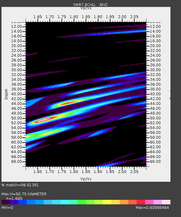
| Estimated Moho Depth: |
50.75 km |
| Estimated Crust Vp/Vs: |
1.66 |
| Assumed Crust Vp: |
6.242 km/s |
| Estimated Crust Vs: |
3.749 km/s |
| Estimated Crust Poisson's Ratio: |
0.22 |
|
| Radial Match: |
86.51381 % |
| Radial Bump: |
400 |
| Transverse Match: |
53.80636 % |
| Transverse Bump: |
400 |
| SOD ConfigId: |
4480 |
| Insert Time: |
2010-02-26 15:19:18.208 +0000 |
| GWidth: |
2.5 |
| Max Bumps: |
400 |
| Tol: |
0.001 |
|
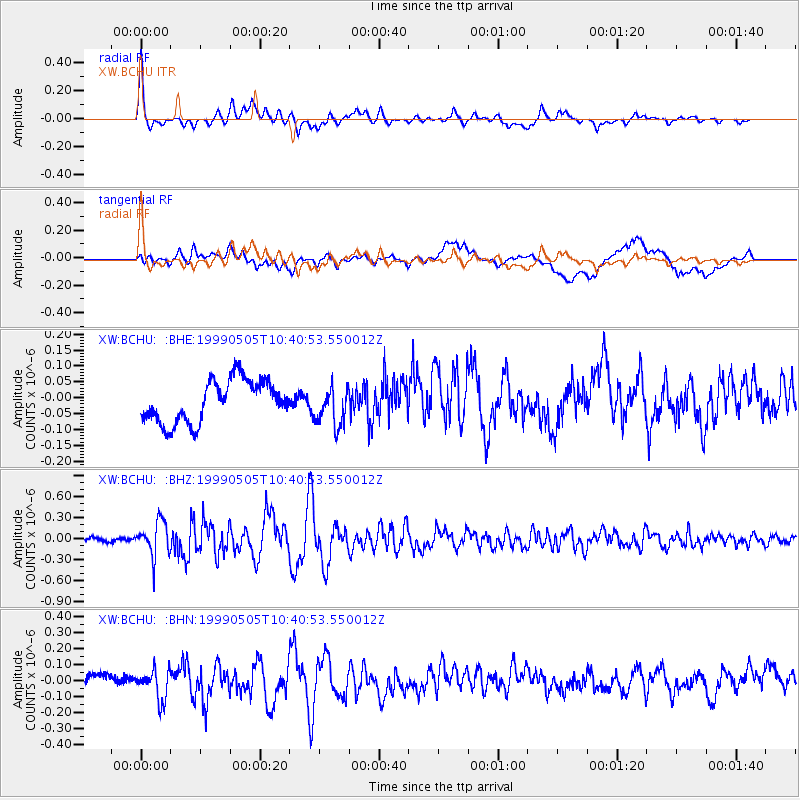
Signal To Noise
| Channel | StoN | STA | LTA |
| XW:BCHU: :BHZ:19990505T10:40:53.550012Z | 6.650615 | 2.47849E-7 | 3.726708E-8 |
| XW:BCHU: :BHN:19990505T10:40:53.550012Z | 2.1700141 | 9.44655E-8 | 4.3532207E-8 |
| XW:BCHU: :BHE:19990505T10:40:53.550012Z | 0.92259085 | 6.104176E-8 | 6.6163416E-8 |
| Arrivals |
| Ps | 5.6 SECOND |
| PpPs | 21 SECOND |
| PsPs/PpSs | 27 SECOND |


