You are here: Home > Network List > TA - USArray Transportable Network (new EarthScope stations) Stations List
> Station I30M Mount Dempster, Yukon, CAN > Earthquake Result Viewer
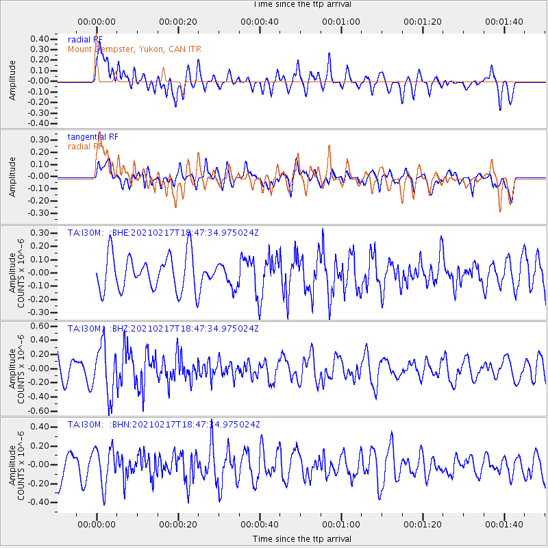
I30M Mount Dempster, Yukon, CAN - Earthquake Result Viewer
*The percent match for this event was below the threshold and hence no stack was calculated.
| Earthquake location: |
Northern And Central Iran |
| Earthquake latitude/longitude: |
30.8/51.4 |
| Earthquake time(UTC): |
2021/02/17 (048) 18:35:35 GMT |
| Earthquake Depth: |
10 km |
| Earthquake Magnitude: |
5.4 Mww |
| Earthquake Catalog/Contributor: |
NEIC PDE/us |
|
| Network: |
TA USArray Transportable Network (new EarthScope stations) |
| Station: |
I30M Mount Dempster, Yukon, CAN |
| Lat/Lon: |
65.22 N/136.38 W |
| Elevation: |
1399 m |
|
| Distance: |
84.1 deg |
| Az: |
3.274 deg |
| Baz: |
353.304 deg |
| Ray Param: |
$rayparam |
*The percent match for this event was below the threshold and hence was not used in the summary stack. |
|
| Radial Match: |
66.550514 % |
| Radial Bump: |
400 |
| Transverse Match: |
46.92702 % |
| Transverse Bump: |
400 |
| SOD ConfigId: |
23341671 |
| Insert Time: |
2021-03-03 19:46:49.834 +0000 |
| GWidth: |
2.5 |
| Max Bumps: |
400 |
| Tol: |
0.001 |
|
Signal To Noise
| Channel | StoN | STA | LTA |
| TA:I30M: :BHZ:20210217T18:47:34.975024Z | 2.0046387 | 3.5311965E-7 | 1.7615126E-7 |
| TA:I30M: :BHN:20210217T18:47:34.975024Z | 1.4960599 | 1.9884723E-7 | 1.3291395E-7 |
| TA:I30M: :BHE:20210217T18:47:34.975024Z | 0.6407342 | 8.7425406E-8 | 1.3644566E-7 |
| Arrivals |
| Ps | |
| PpPs | |
| PsPs/PpSs | |


