You are here: Home > Network List > GE - GEOFON Stations List
> Station SNAA AWI/GEOFON Station Sanae, Antarctica > Earthquake Result Viewer
SNAA AWI/GEOFON Station Sanae, Antarctica - Earthquake Result Viewer
| Earthquake location: |
Santa Cruz Islands |
| Earthquake latitude/longitude: |
-12.9/166.5 |
| Earthquake time(UTC): |
1997/04/21 (111) 12:06:34 GMT |
| Earthquake Depth: |
33 km |
| Earthquake Magnitude: |
6.1 MB |
| Earthquake Catalog/Contributor: |
WHDF/NEIC |
|
| Network: |
GE GEOFON |
| Station: |
SNAA AWI/GEOFON Station Sanae, Antarctica |
| Lat/Lon: |
71.67 S/2.84 W |
| Elevation: |
846 m |
|
| Distance: |
95.3 deg |
| Az: |
183.382 deg |
| Baz: |
169.525 deg |
| Ray Param: |
0.040794384 |
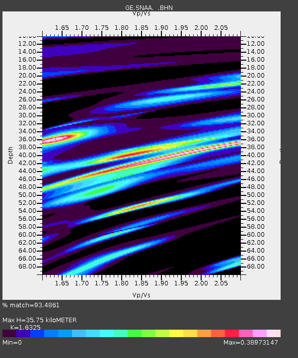
| Estimated Moho Depth: |
35.75 km |
| Estimated Crust Vp/Vs: |
1.63 |
| Assumed Crust Vp: |
6.43 km/s |
| Estimated Crust Vs: |
3.939 km/s |
| Estimated Crust Poisson's Ratio: |
0.20 |
|
| Radial Match: |
93.4861 % |
| Radial Bump: |
340 |
| Transverse Match: |
58.397324 % |
| Transverse Bump: |
400 |
| SOD ConfigId: |
6273 |
| Insert Time: |
2010-03-09 05:36:52.206 +0000 |
| GWidth: |
2.5 |
| Max Bumps: |
400 |
| Tol: |
0.001 |
|
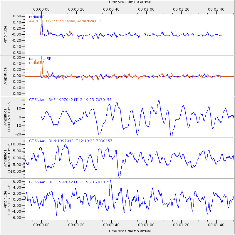
Signal To Noise
| Channel | StoN | STA | LTA |
| GE:SNAA: :BHN:19970421T12:19:23.703015Z | 2.425735 | 6.101254E-6 | 2.5152187E-6 |
| GE:SNAA: :BHE:19970421T12:19:23.703015Z | 0.881791 | 1.4466804E-6 | 1.6406159E-6 |
| GE:SNAA: :BHZ:19970421T12:19:23.703015Z | 2.4022014 | 1.2447817E-5 | 5.1818374E-6 |
| Arrivals |
| Ps | 3.6 SECOND |
| PpPs | 14 SECOND |
| PsPs/PpSs | 18 SECOND |


