You are here: Home > Network List > GE - GEOFON Stations List
> Station SNAA AWI/GEOFON Station Sanae, Antarctica > Earthquake Result Viewer
SNAA AWI/GEOFON Station Sanae, Antarctica - Earthquake Result Viewer
| Earthquake location: |
South Of Kermadec Islands |
| Earthquake latitude/longitude: |
-32.1/179.8 |
| Earthquake time(UTC): |
1997/05/25 (145) 23:22:33 GMT |
| Earthquake Depth: |
333 km |
| Earthquake Magnitude: |
6.2 MB, 7.1 UNKNOWN, 7.0 MW |
| Earthquake Catalog/Contributor: |
WHDF/NEIC |
|
| Network: |
GE GEOFON |
| Station: |
SNAA AWI/GEOFON Station Sanae, Antarctica |
| Lat/Lon: |
71.67 S/2.84 W |
| Elevation: |
846 m |
|
| Distance: |
76.5 deg |
| Az: |
179.145 deg |
| Baz: |
182.294 deg |
| Ray Param: |
0.05003172 |
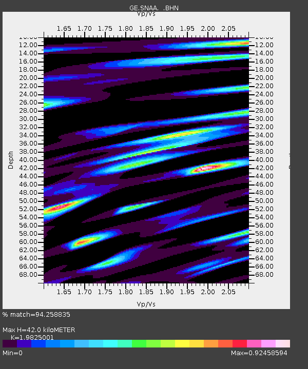
| Estimated Moho Depth: |
42.0 km |
| Estimated Crust Vp/Vs: |
1.98 |
| Assumed Crust Vp: |
6.43 km/s |
| Estimated Crust Vs: |
3.243 km/s |
| Estimated Crust Poisson's Ratio: |
0.33 |
|
| Radial Match: |
94.258835 % |
| Radial Bump: |
373 |
| Transverse Match: |
91.025444 % |
| Transverse Bump: |
400 |
| SOD ConfigId: |
6273 |
| Insert Time: |
2010-03-09 05:36:56.422 +0000 |
| GWidth: |
2.5 |
| Max Bumps: |
400 |
| Tol: |
0.001 |
|

Signal To Noise
| Channel | StoN | STA | LTA |
| GE:SNAA: :BHN:19970525T23:33:15.902002Z | 4.0199723 | 1.9117883E-6 | 4.7557248E-7 |
| GE:SNAA: :BHE:19970525T23:33:15.902002Z | 1.8666154 | 7.24298E-7 | 3.8802744E-7 |
| GE:SNAA: :BHZ:19970525T23:33:15.902002Z | 6.516898 | 4.3620275E-6 | 6.693411E-7 |
| Arrivals |
| Ps | 6.6 SECOND |
| PpPs | 19 SECOND |
| PsPs/PpSs | 26 SECOND |


