SNAA AWI/GEOFON Station Sanae, Antarctica - Earthquake Result Viewer
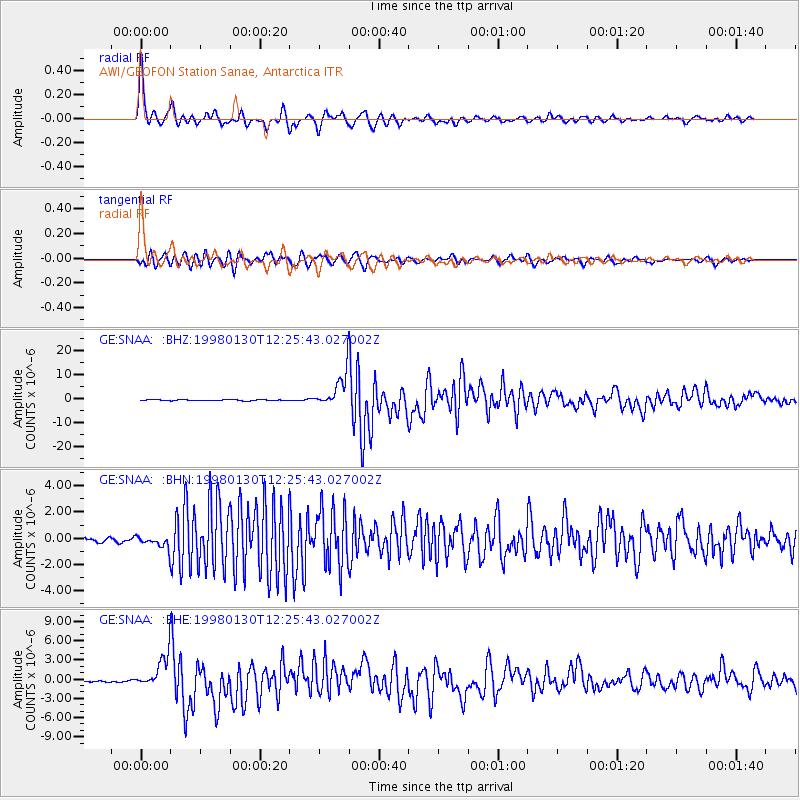
Earthquake location: Near Coast Of Northern Chile
Earthquake latitude/longitude: -23.9/-70.2
Earthquake time(UTC): 1998/01/30 (030) 12:16:08 GMT
Earthquake Depth: 42 km
Earthquake Magnitude: 6.3 MB, 6.5 MS, 7.0 UNKNOWN, 6.7 ME
Earthquake Catalog/Contributor: WHDF/NEIC
Network: GE GEOFON
Station: SNAA AWI/GEOFON Station Sanae, Antarctica
Lat/Lon: 71.67 S/2.84 W
Elevation: 846 m
Distance: 60.4 deg
Az: 160.377 deg
Baz: 283.739 deg
Ray Param: 0.061464787
Estimated Moho Depth: 43.0 km
Estimated Crust Vp/Vs: 1.64
Assumed Crust Vp: 6.43 km/s
Estimated Crust Vs: 3.927 km/s
Estimated Crust Poisson's Ratio: 0.20
Radial Match: 94.55634 %
Radial Bump: 400
Transverse Match: 89.51177 %
Transverse Bump: 400
SOD ConfigId: 6273
Insert Time: 2010-03-09 05:37:01.211 +0000
GWidth: 2.5
Max Bumps: 400
Tol: 0.001

Signal To Noise

ChannelStoNSTALTA
GE:SNAA: :BHN:19980130T12:25:43.027002Z2.63257054.9792004E-71.8913836E-7
GE:SNAA: :BHE:19980130T12:25:43.027002Z11.4383342.6786279E-62.3417988E-7
GE:SNAA: :BHZ:19980130T12:25:43.027002Z34.531146.9323064E-62.0075522E-7
Arrivals
Ps4.5 SECOND
PpPs17 SECOND
PsPs/PpSs21 SECOND