You are here: Home > Network List > AZ - ANZA Regional Network Stations List
> Station SMER AZ.SMER > Earthquake Result Viewer
SMER AZ.SMER - Earthquake Result Viewer
*The percent match for this event was below the threshold and hence no stack was calculated.
| Earthquake location: |
Southeast Of Loyalty Islands |
| Earthquake latitude/longitude: |
-23.2/171.8 |
| Earthquake time(UTC): |
2021/02/17 (048) 22:49:38 GMT |
| Earthquake Depth: |
13 km |
| Earthquake Magnitude: |
6.1 Mww |
| Earthquake Catalog/Contributor: |
NEIC PDE/us |
|
| Network: |
AZ ANZA Regional Network |
| Station: |
SMER AZ.SMER |
| Lat/Lon: |
33.46 N/117.17 W |
| Elevation: |
355 m |
|
| Distance: |
88.0 deg |
| Az: |
52.303 deg |
| Baz: |
240.566 deg |
| Ray Param: |
$rayparam |
*The percent match for this event was below the threshold and hence was not used in the summary stack. |
|
| Radial Match: |
59.159595 % |
| Radial Bump: |
400 |
| Transverse Match: |
51.44671 % |
| Transverse Bump: |
400 |
| SOD ConfigId: |
23341671 |
| Insert Time: |
2021-03-03 23:56:10.182 +0000 |
| GWidth: |
2.5 |
| Max Bumps: |
400 |
| Tol: |
0.001 |
|
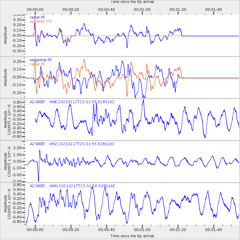
Signal To Noise
| Channel | StoN | STA | LTA |
| AZ:SMER: :HHZ:20210217T23:01:56.628019Z | 2.668631 | 9.289983E-7 | 3.4811794E-7 |
| AZ:SMER: :HHN:20210217T23:01:56.628019Z | 1.3365415 | 5.05763E-7 | 3.7841173E-7 |
| AZ:SMER: :HHE:20210217T23:01:56.628019Z | 1.5835203 | 4.938436E-7 | 3.1186437E-7 |
| Arrivals |
| Ps | |
| PpPs | |
| PsPs/PpSs | |


