You are here: Home > Network List > GE - GEOFON Stations List
> Station SNAA GEOFON/AWI Station Sanae, Antarctica > Earthquake Result Viewer
SNAA GEOFON/AWI Station Sanae, Antarctica - Earthquake Result Viewer
| Earthquake location: |
Southern Sumatra, Indonesia |
| Earthquake latitude/longitude: |
-0.7/99.9 |
| Earthquake time(UTC): |
2009/09/30 (273) 10:16:09 GMT |
| Earthquake Depth: |
81 km |
| Earthquake Magnitude: |
7.1 MB, 7.5 MW, 7.5 MW |
| Earthquake Catalog/Contributor: |
WHDF/NEIC |
|
| Network: |
GE GEOFON |
| Station: |
SNAA GEOFON/AWI Station Sanae, Antarctica |
| Lat/Lon: |
71.67 S/2.84 W |
| Elevation: |
846 m |
|
| Distance: |
93.3 deg |
| Az: |
198.008 deg |
| Baz: |
102.294 deg |
| Ray Param: |
0.04124483 |
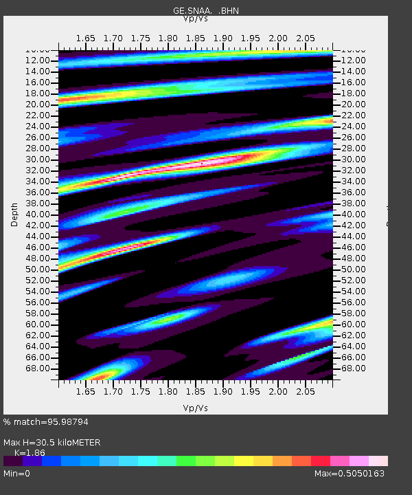
| Estimated Moho Depth: |
30.5 km |
| Estimated Crust Vp/Vs: |
1.86 |
| Assumed Crust Vp: |
6.43 km/s |
| Estimated Crust Vs: |
3.457 km/s |
| Estimated Crust Poisson's Ratio: |
0.30 |
|
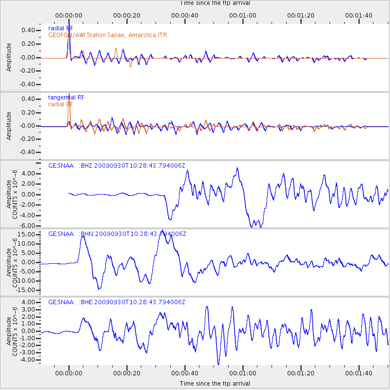
| Radial Match: |
95.98794 % |
| Radial Bump: |
400 |
| Transverse Match: |
88.18477 % |
| Transverse Bump: |
400 |
| SOD ConfigId: |
2622 |
| Insert Time: |
2010-03-09 05:37:52.362 +0000 |
| GWidth: |
2.5 |
| Max Bumps: |
400 |
| Tol: |
0.001 |
|
Signal To Noise
| Channel | StoN | STA | LTA |
| GE:SNAA: :BHN:20090930T10:28:43.794006Z | 39.62093 | 5.856829E-6 | 1.478216E-7 |
| GE:SNAA: :BHE:20090930T10:28:43.794006Z | 7.5638356 | 6.1446315E-7 | 8.123698E-8 |
| GE:SNAA: :BHZ:20090930T10:28:43.794006Z | 12.171891 | 1.7723211E-6 | 1.456077E-7 |
| Arrivals |
| Ps | 4.2 SECOND |
| PpPs | 13 SECOND |
| PsPs/PpSs | 17 SECOND |


