You are here: Home > Network List > TA - USArray Transportable Network (new EarthScope stations) Stations List
> Station E20K Nigu River, AK, USA > Earthquake Result Viewer
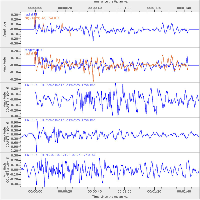
E20K Nigu River, AK, USA - Earthquake Result Viewer
*The percent match for this event was below the threshold and hence no stack was calculated.
| Earthquake location: |
Southeast Of Loyalty Islands |
| Earthquake latitude/longitude: |
-23.2/171.8 |
| Earthquake time(UTC): |
2021/02/17 (048) 22:49:38 GMT |
| Earthquake Depth: |
13 km |
| Earthquake Magnitude: |
6.1 Mww |
| Earthquake Catalog/Contributor: |
NEIC PDE/us |
|
| Network: |
TA USArray Transportable Network (new EarthScope stations) |
| Station: |
E20K Nigu River, AK, USA |
| Lat/Lon: |
68.26 N/156.19 W |
| Elevation: |
866 m |
|
| Distance: |
94.2 deg |
| Az: |
11.435 deg |
| Baz: |
209.316 deg |
| Ray Param: |
$rayparam |
*The percent match for this event was below the threshold and hence was not used in the summary stack. |
|
| Radial Match: |
67.46541 % |
| Radial Bump: |
400 |
| Transverse Match: |
52.92646 % |
| Transverse Bump: |
400 |
| SOD ConfigId: |
23341671 |
| Insert Time: |
2021-03-04 00:04:55.911 +0000 |
| GWidth: |
2.5 |
| Max Bumps: |
400 |
| Tol: |
0.001 |
|
Signal To Noise
| Channel | StoN | STA | LTA |
| TA:E20K: :BHZ:20210217T23:02:25.175016Z | 3.1801085 | 4.3124103E-7 | 1.3560576E-7 |
| TA:E20K: :BHN:20210217T23:02:25.175016Z | 1.4150105 | 1.17639956E-7 | 8.313717E-8 |
| TA:E20K: :BHE:20210217T23:02:25.175016Z | 1.7002708 | 1.12075256E-7 | 6.591612E-8 |
| Arrivals |
| Ps | |
| PpPs | |
| PsPs/PpSs | |


