You are here: Home > Network List > TA - USArray Transportable Network (new EarthScope stations) Stations List
> Station F24K Squaw Lake, AK, USA > Earthquake Result Viewer
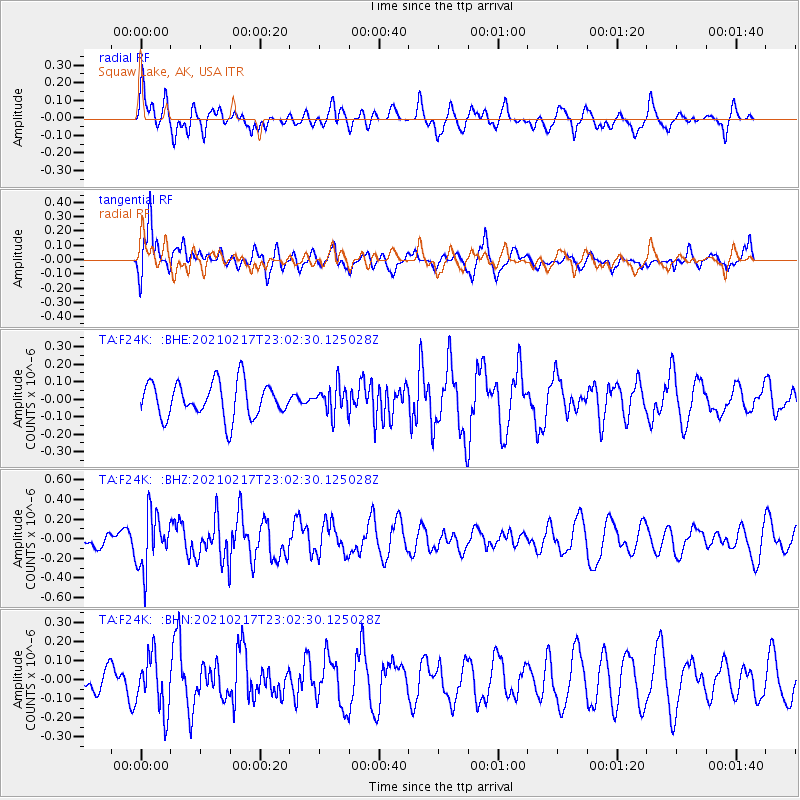
F24K Squaw Lake, AK, USA - Earthquake Result Viewer
*The percent match for this event was below the threshold and hence no stack was calculated.
| Earthquake location: |
Southeast Of Loyalty Islands |
| Earthquake latitude/longitude: |
-23.2/171.8 |
| Earthquake time(UTC): |
2021/02/17 (048) 22:49:38 GMT |
| Earthquake Depth: |
13 km |
| Earthquake Magnitude: |
6.1 Mww |
| Earthquake Catalog/Contributor: |
NEIC PDE/us |
|
| Network: |
TA USArray Transportable Network (new EarthScope stations) |
| Station: |
F24K Squaw Lake, AK, USA |
| Lat/Lon: |
67.52 N/147.89 W |
| Elevation: |
736 m |
|
| Distance: |
95.3 deg |
| Az: |
14.482 deg |
| Baz: |
216.75 deg |
| Ray Param: |
$rayparam |
*The percent match for this event was below the threshold and hence was not used in the summary stack. |
|
| Radial Match: |
48.88263 % |
| Radial Bump: |
400 |
| Transverse Match: |
61.463623 % |
| Transverse Bump: |
400 |
| SOD ConfigId: |
23341671 |
| Insert Time: |
2021-03-04 00:05:04.438 +0000 |
| GWidth: |
2.5 |
| Max Bumps: |
400 |
| Tol: |
0.001 |
|
Signal To Noise
| Channel | StoN | STA | LTA |
| TA:F24K: :BHZ:20210217T23:02:30.125028Z | 2.850193 | 2.8177138E-7 | 9.8860454E-8 |
| TA:F24K: :BHN:20210217T23:02:30.125028Z | 1.5757076 | 1.4502491E-7 | 9.2037965E-8 |
| TA:F24K: :BHE:20210217T23:02:30.125028Z | 0.79181635 | 7.905785E-8 | 9.984367E-8 |
| Arrivals |
| Ps | |
| PpPs | |
| PsPs/PpSs | |


