You are here: Home > Network List > UW - Pacific Northwest Regional Seismic Network Stations List
> Station GNW Green Mountain (BB) > Earthquake Result Viewer
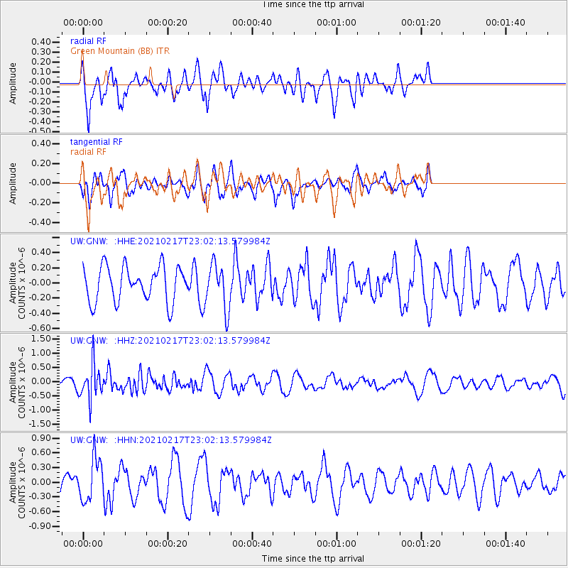
GNW Green Mountain (BB) - Earthquake Result Viewer
*The percent match for this event was below the threshold and hence no stack was calculated.
| Earthquake location: |
Southeast Of Loyalty Islands |
| Earthquake latitude/longitude: |
-23.2/171.8 |
| Earthquake time(UTC): |
2021/02/17 (048) 22:49:38 GMT |
| Earthquake Depth: |
13 km |
| Earthquake Magnitude: |
6.1 Mww |
| Earthquake Catalog/Contributor: |
NEIC PDE/us |
|
| Network: |
UW Pacific Northwest Regional Seismic Network |
| Station: |
GNW Green Mountain (BB) |
| Lat/Lon: |
47.56 N/122.83 W |
| Elevation: |
160 m |
|
| Distance: |
91.7 deg |
| Az: |
38.031 deg |
| Baz: |
236.835 deg |
| Ray Param: |
$rayparam |
*The percent match for this event was below the threshold and hence was not used in the summary stack. |
|
| Radial Match: |
65.35227 % |
| Radial Bump: |
334 |
| Transverse Match: |
44.94229 % |
| Transverse Bump: |
379 |
| SOD ConfigId: |
23341671 |
| Insert Time: |
2021-03-04 00:08:07.894 +0000 |
| GWidth: |
2.5 |
| Max Bumps: |
400 |
| Tol: |
0.001 |
|
Signal To Noise
| Channel | StoN | STA | LTA |
| UW:GNW: :HHZ:20210217T23:02:13.579984Z | 4.5351872 | 5.979618E-7 | 1.3184942E-7 |
| UW:GNW: :HHN:20210217T23:02:13.579984Z | 1.6581208 | 4.4377703E-7 | 2.6763854E-7 |
| UW:GNW: :HHE:20210217T23:02:13.579984Z | 1.3175426 | 3.024858E-7 | 2.2958332E-7 |
| Arrivals |
| Ps | |
| PpPs | |
| PsPs/PpSs | |


