You are here: Home > Network List > UW - Pacific Northwest Regional Seismic Network Stations List
> Station YACT Amboy, WA, USA > Earthquake Result Viewer
YACT Amboy, WA, USA - Earthquake Result Viewer
| Earthquake location: |
Southeast Of Loyalty Islands |
| Earthquake latitude/longitude: |
-23.2/171.8 |
| Earthquake time(UTC): |
2021/02/17 (048) 22:49:38 GMT |
| Earthquake Depth: |
13 km |
| Earthquake Magnitude: |
6.1 Mww |
| Earthquake Catalog/Contributor: |
NEIC PDE/us |
|
| Network: |
UW Pacific Northwest Regional Seismic Network |
| Station: |
YACT Amboy, WA, USA |
| Lat/Lon: |
45.93 N/122.42 W |
| Elevation: |
211 m |
|
| Distance: |
91.0 deg |
| Az: |
39.552 deg |
| Baz: |
237.095 deg |
| Ray Param: |
0.041656666 |
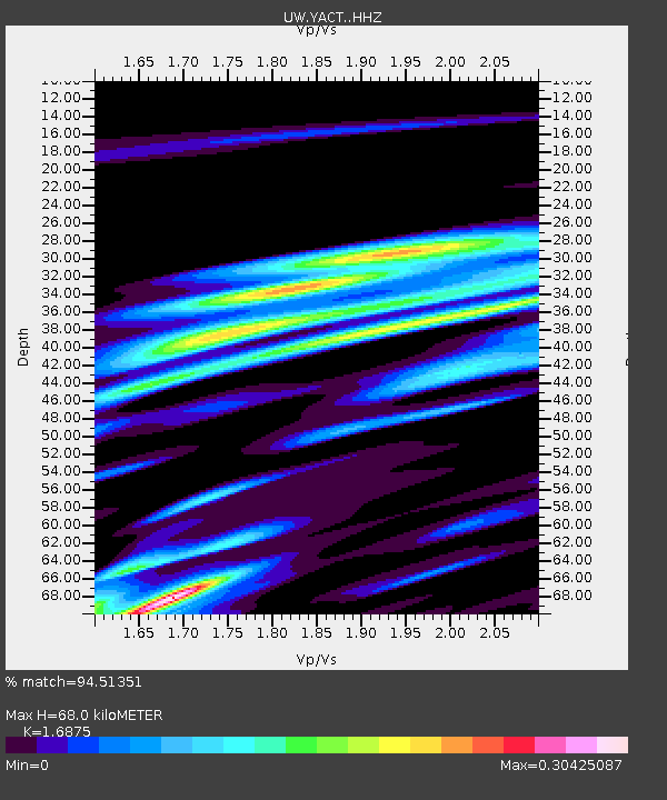
| Estimated Moho Depth: |
68.0 km |
| Estimated Crust Vp/Vs: |
1.69 |
| Assumed Crust Vp: |
6.566 km/s |
| Estimated Crust Vs: |
3.891 km/s |
| Estimated Crust Poisson's Ratio: |
0.23 |
|
| Radial Match: |
94.51351 % |
| Radial Bump: |
259 |
| Transverse Match: |
94.5135 % |
| Transverse Bump: |
259 |
| SOD ConfigId: |
23341671 |
| Insert Time: |
2021-03-04 00:08:48.707 +0000 |
| GWidth: |
2.5 |
| Max Bumps: |
400 |
| Tol: |
0.001 |
|
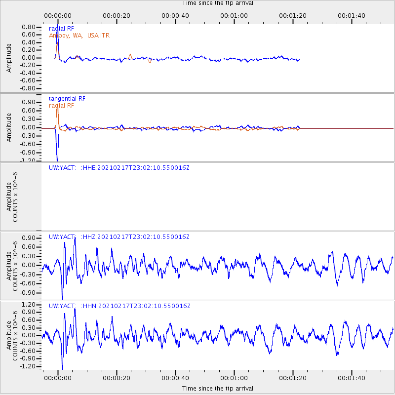
Signal To Noise
| Channel | StoN | STA | LTA |
| UW:YACT: :HHZ:20210217T23:02:10.550016Z | 2.6108475 | 3.8750798E-7 | 1.484223E-7 |
| UW:YACT: :HHN:20210217T23:02:10.550016Z | 2.449345 | 4.545875E-7 | 1.8559554E-7 |
| $trig.getChannelId() | $trig.getValue() | $trig.getSTA() | $trig.getLTA() |
| Arrivals |
| Ps | 7.3 SECOND |
| PpPs | 27 SECOND |
| PsPs/PpSs | 34 SECOND |


