You are here: Home > Network List > WY - Yellowstone Wyoming Seismic Network Stations List
> Station YFT Old Faithful, YNP, WY, USA > Earthquake Result Viewer
YFT Old Faithful, YNP, WY, USA - Earthquake Result Viewer
| Earthquake location: |
Southeast Of Loyalty Islands |
| Earthquake latitude/longitude: |
-23.2/171.8 |
| Earthquake time(UTC): |
2021/02/17 (048) 22:49:38 GMT |
| Earthquake Depth: |
13 km |
| Earthquake Magnitude: |
6.1 Mww |
| Earthquake Catalog/Contributor: |
NEIC PDE/us |
|
| Network: |
WY Yellowstone Wyoming Seismic Network |
| Station: |
YFT Old Faithful, YNP, WY, USA |
| Lat/Lon: |
44.45 N/110.84 W |
| Elevation: |
2292 m |
|
| Distance: |
97.4 deg |
| Az: |
44.821 deg |
| Baz: |
244.912 deg |
| Ray Param: |
0.04021444 |
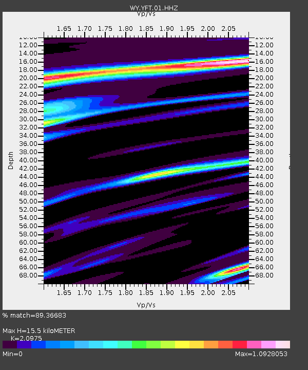
| Estimated Moho Depth: |
15.5 km |
| Estimated Crust Vp/Vs: |
2.10 |
| Assumed Crust Vp: |
6.35 km/s |
| Estimated Crust Vs: |
3.027 km/s |
| Estimated Crust Poisson's Ratio: |
0.35 |
|
| Radial Match: |
89.36683 % |
| Radial Bump: |
247 |
| Transverse Match: |
57.815723 % |
| Transverse Bump: |
254 |
| SOD ConfigId: |
23341671 |
| Insert Time: |
2021-03-04 00:09:00.686 +0000 |
| GWidth: |
2.5 |
| Max Bumps: |
400 |
| Tol: |
0.001 |
|

Signal To Noise
| Channel | StoN | STA | LTA |
| WY:YFT:01:HHZ:20210217T23:02:39.920011Z | 1.4025488 | 1.2414364E-8 | 8.851288E-9 |
| WY:YFT:01:HHN:20210217T23:02:39.920011Z | 2.7611544 | 6.314362E-8 | 2.2868557E-8 |
| WY:YFT:01:HHE:20210217T23:02:39.920011Z | 2.3904827 | 5.5961586E-8 | 2.3410161E-8 |
| Arrivals |
| Ps | 2.7 SECOND |
| PpPs | 7.4 SECOND |
| PsPs/PpSs | 10 SECOND |


