You are here: Home > Network List > GE - GEOFON Stations List
> Station SNAA AWI/GEOFON Station Sanae, Antarctica > Earthquake Result Viewer
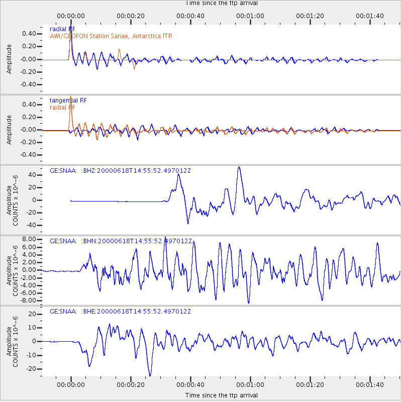
SNAA AWI/GEOFON Station Sanae, Antarctica - Earthquake Result Viewer
| Earthquake location: |
South Indian Ocean |
| Earthquake latitude/longitude: |
-13.8/97.5 |
| Earthquake time(UTC): |
2000/06/18 (170) 14:44:13 GMT |
| Earthquake Depth: |
10 km |
| Earthquake Magnitude: |
6.8 MB, 7.8 MS, 7.8 MW, 7.6 MW |
| Earthquake Catalog/Contributor: |
WHDF/NEIC |
|
| Network: |
GE GEOFON |
| Station: |
SNAA AWI/GEOFON Station Sanae, Antarctica |
| Lat/Lon: |
71.67 S/2.84 W |
| Elevation: |
846 m |
|
| Distance: |
80.2 deg |
| Az: |
198.415 deg |
| Baz: |
104.074 deg |
| Ray Param: |
0.048429728 |
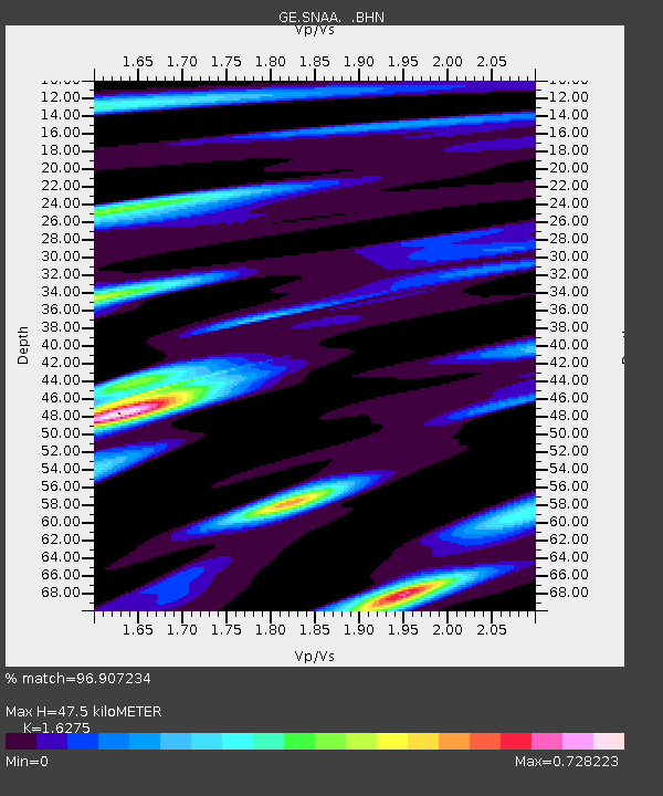
| Estimated Moho Depth: |
47.5 km |
| Estimated Crust Vp/Vs: |
1.63 |
| Assumed Crust Vp: |
6.43 km/s |
| Estimated Crust Vs: |
3.951 km/s |
| Estimated Crust Poisson's Ratio: |
0.20 |
|
| Radial Match: |
96.907234 % |
| Radial Bump: |
400 |
| Transverse Match: |
88.60808 % |
| Transverse Bump: |
400 |
| SOD ConfigId: |
3744 |
| Insert Time: |
2010-03-09 05:39:01.950 +0000 |
| GWidth: |
2.5 |
| Max Bumps: |
400 |
| Tol: |
0.001 |
|
Signal To Noise
| Channel | StoN | STA | LTA |
| GE:SNAA: :BHN:20000618T14:55:52.497012Z | 3.457036 | 6.976579E-7 | 2.0180812E-7 |
| GE:SNAA: :BHE:20000618T14:55:52.497012Z | 18.26163 | 3.659634E-6 | 2.0040021E-7 |
| GE:SNAA: :BHZ:20000618T14:55:52.497012Z | 25.667475 | 8.905312E-6 | 3.4694926E-7 |
| Arrivals |
| Ps | 4.8 SECOND |
| PpPs | 19 SECOND |
| PsPs/PpSs | 24 SECOND |


