You are here: Home > Network List > GE - GEOFON Stations List
> Station SNAA AWI/GEOFON Station Sanae, Antarctica > Earthquake Result Viewer
SNAA AWI/GEOFON Station Sanae, Antarctica - Earthquake Result Viewer
| Earthquake location: |
Vanuatu Islands |
| Earthquake latitude/longitude: |
-15.4/166.9 |
| Earthquake time(UTC): |
2000/10/04 (278) 16:58:44 GMT |
| Earthquake Depth: |
23 km |
| Earthquake Magnitude: |
6.1 MB, 6.9 MS, 6.8 MW, 6.5 ME |
| Earthquake Catalog/Contributor: |
WHDF/NEIC |
|
| Network: |
GE GEOFON |
| Station: |
SNAA AWI/GEOFON Station Sanae, Antarctica |
| Lat/Lon: |
71.67 S/2.84 W |
| Elevation: |
846 m |
|
| Distance: |
92.8 deg |
| Az: |
183.232 deg |
| Baz: |
170.104 deg |
| Ray Param: |
0.041372597 |
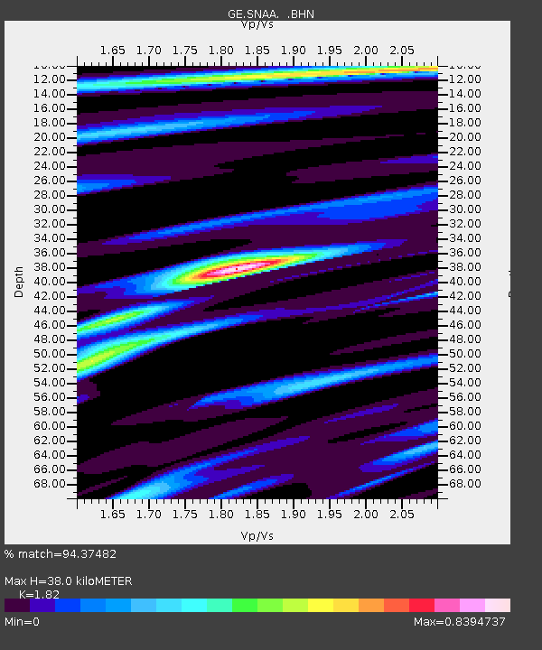
| Estimated Moho Depth: |
38.0 km |
| Estimated Crust Vp/Vs: |
1.82 |
| Assumed Crust Vp: |
6.43 km/s |
| Estimated Crust Vs: |
3.533 km/s |
| Estimated Crust Poisson's Ratio: |
0.28 |
|
| Radial Match: |
94.37482 % |
| Radial Bump: |
400 |
| Transverse Match: |
73.17064 % |
| Transverse Bump: |
400 |
| SOD ConfigId: |
3744 |
| Insert Time: |
2010-03-09 05:39:10.419 +0000 |
| GWidth: |
2.5 |
| Max Bumps: |
400 |
| Tol: |
0.001 |
|
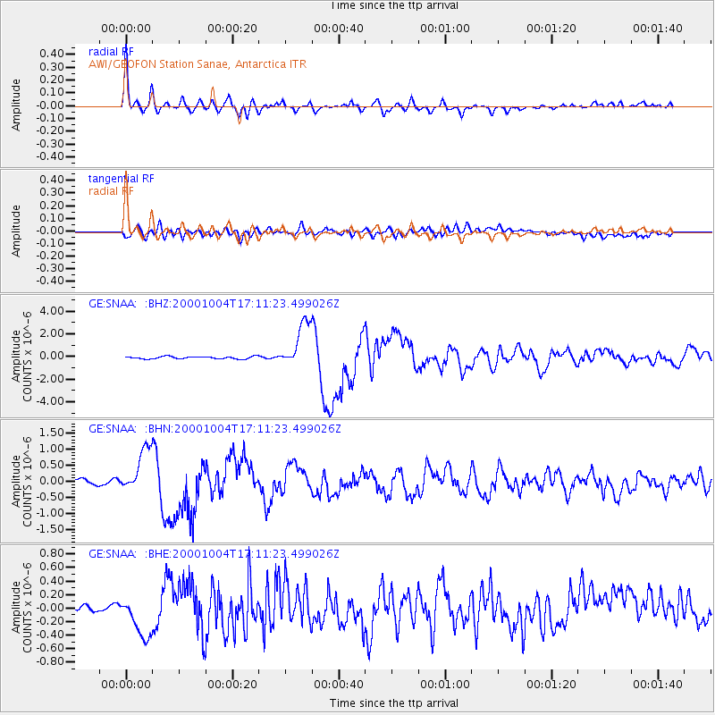
Signal To Noise
| Channel | StoN | STA | LTA |
| GE:SNAA: :BHN:20001004T17:11:23.499026Z | 7.398027 | 7.148823E-7 | 9.6631474E-8 |
| GE:SNAA: :BHE:20001004T17:11:23.499026Z | 4.2689285 | 2.883514E-7 | 6.754655E-8 |
| GE:SNAA: :BHZ:20001004T17:11:23.499026Z | 19.823048 | 2.0724574E-6 | 1.0454787E-7 |
| Arrivals |
| Ps | 4.9 SECOND |
| PpPs | 16 SECOND |
| PsPs/PpSs | 21 SECOND |


