You are here: Home > Network List > GE - GEOFON Stations List
> Station SNAA AWI/GEOFON Station Sanae, Antarctica > Earthquake Result Viewer
SNAA AWI/GEOFON Station Sanae, Antarctica - Earthquake Result Viewer
| Earthquake location: |
Fiji Islands Region |
| Earthquake latitude/longitude: |
-20.9/-178.7 |
| Earthquake time(UTC): |
1999/03/23 (082) 11:23:44 GMT |
| Earthquake Depth: |
575 km |
| Earthquake Magnitude: |
5.7 MW, 5.0 MB, 5.6 MW |
| Earthquake Catalog/Contributor: |
WHDF/NEIC |
|
| Network: |
GE GEOFON |
| Station: |
SNAA AWI/GEOFON Station Sanae, Antarctica |
| Lat/Lon: |
71.67 S/2.84 W |
| Elevation: |
846 m |
|
| Distance: |
87.6 deg |
| Az: |
178.701 deg |
| Baz: |
183.843 deg |
| Ray Param: |
0.041717228 |
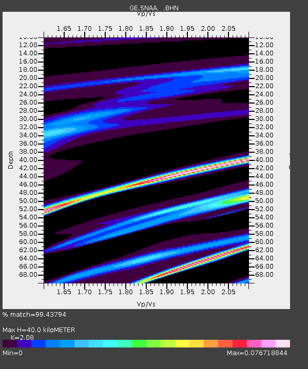
| Estimated Moho Depth: |
40.0 km |
| Estimated Crust Vp/Vs: |
2.08 |
| Assumed Crust Vp: |
6.43 km/s |
| Estimated Crust Vs: |
3.091 km/s |
| Estimated Crust Poisson's Ratio: |
0.35 |
|
| Radial Match: |
99.43794 % |
| Radial Bump: |
107 |
| Transverse Match: |
99.123825 % |
| Transverse Bump: |
150 |
| SOD ConfigId: |
4480 |
| Insert Time: |
2010-03-09 05:39:25.486 +0000 |
| GWidth: |
2.5 |
| Max Bumps: |
400 |
| Tol: |
0.001 |
|
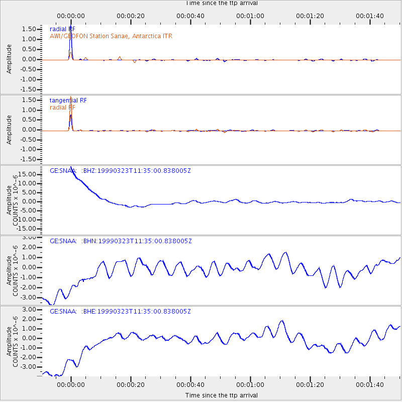
Signal To Noise
| Channel | StoN | STA | LTA |
| GE:SNAA: :BHN:19990323T11:35:00.838005Z | 0.70792526 | 6.4756205E-6 | 9.147322E-6 |
| GE:SNAA: :BHE:19990323T11:35:00.838005Z | 0.7306823 | 8.038785E-6 | 1.1001752E-5 |
| GE:SNAA: :BHZ:19990323T11:35:00.838005Z | 0.6842924 | 4.181675E-6 | 6.1109486E-6 |
| Arrivals |
| Ps | 6.8 SECOND |
| PpPs | 19 SECOND |
| PsPs/PpSs | 26 SECOND |


