You are here: Home > Network List > GE - GEOFON Stations List
> Station SNAA AWI/GEOFON Station Sanae, Antarctica > Earthquake Result Viewer
SNAA AWI/GEOFON Station Sanae, Antarctica - Earthquake Result Viewer
| Earthquake location: |
Near Coast Of Peru |
| Earthquake latitude/longitude: |
-16.7/-72.7 |
| Earthquake time(UTC): |
1999/04/03 (093) 06:17:18 GMT |
| Earthquake Depth: |
87 km |
| Earthquake Magnitude: |
6.1 MB, 6.2 MS, 6.8 MW, 6.8 MW |
| Earthquake Catalog/Contributor: |
WHDF/NEIC |
|
| Network: |
GE GEOFON |
| Station: |
SNAA AWI/GEOFON Station Sanae, Antarctica |
| Lat/Lon: |
71.67 S/2.84 W |
| Elevation: |
846 m |
|
| Distance: |
68.0 deg |
| Az: |
161.317 deg |
| Baz: |
283.949 deg |
| Ray Param: |
0.056386616 |
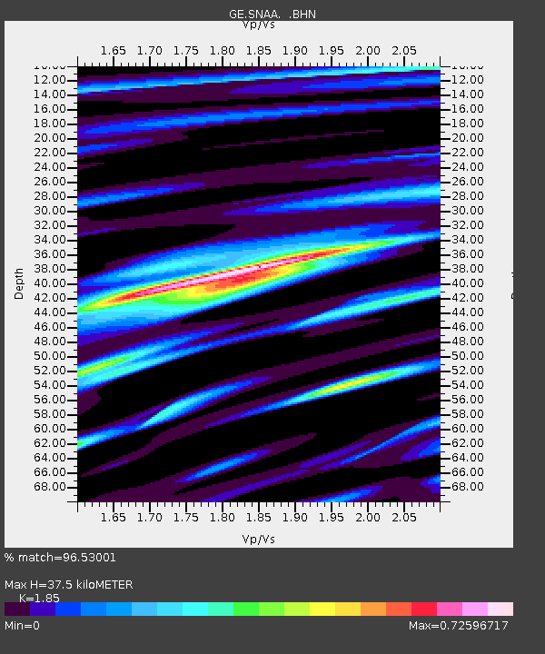
| Estimated Moho Depth: |
37.5 km |
| Estimated Crust Vp/Vs: |
1.85 |
| Assumed Crust Vp: |
6.43 km/s |
| Estimated Crust Vs: |
3.476 km/s |
| Estimated Crust Poisson's Ratio: |
0.29 |
|
| Radial Match: |
96.53001 % |
| Radial Bump: |
400 |
| Transverse Match: |
89.372314 % |
| Transverse Bump: |
400 |
| SOD ConfigId: |
4480 |
| Insert Time: |
2010-03-09 05:39:26.895 +0000 |
| GWidth: |
2.5 |
| Max Bumps: |
400 |
| Tol: |
0.001 |
|
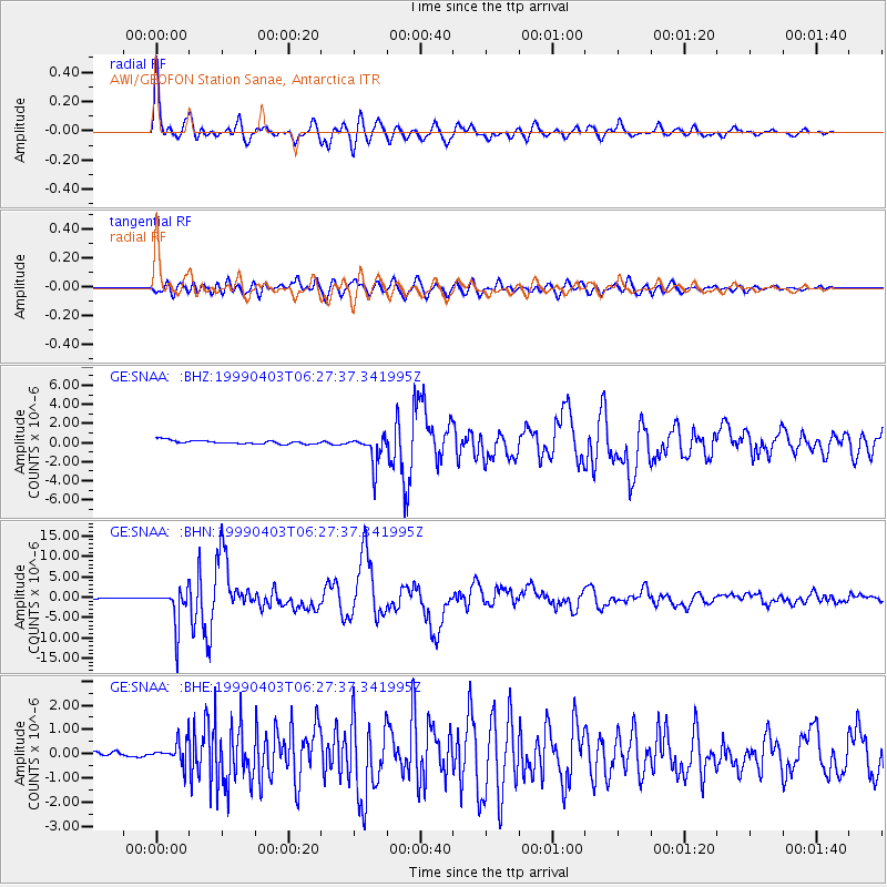
Signal To Noise
| Channel | StoN | STA | LTA |
| GE:SNAA: :BHN:19990403T06:27:37.341995Z | 32.963787 | 4.5639686E-6 | 1.3845401E-7 |
| GE:SNAA: :BHE:19990403T06:27:37.341995Z | 2.568292 | 4.8060707E-7 | 1.8713101E-7 |
| GE:SNAA: :BHZ:19990403T06:27:37.341995Z | 8.202249 | 1.55245E-6 | 1.8927126E-7 |
| Arrivals |
| Ps | 5.1 SECOND |
| PpPs | 16 SECOND |
| PsPs/PpSs | 21 SECOND |


