You are here: Home > Network List > GE - GEOFON Stations List
> Station SNAA AWI/GEOFON Station Sanae, Antarctica > Earthquake Result Viewer
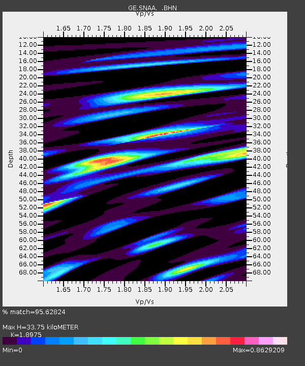
SNAA AWI/GEOFON Station Sanae, Antarctica - Earthquake Result Viewer
| Earthquake location: |
South Of Australia |
| Earthquake latitude/longitude: |
-42.8/124.7 |
| Earthquake time(UTC): |
2001/12/12 (346) 14:02:35 GMT |
| Earthquake Depth: |
10 km |
| Earthquake Magnitude: |
6.5 MB, 6.7 MS, 7.1 MW, 7.0 MW |
| Earthquake Catalog/Contributor: |
WHDF/NEIC |
|
| Network: |
GE GEOFON |
| Station: |
SNAA AWI/GEOFON Station Sanae, Antarctica |
| Lat/Lon: |
71.67 S/2.84 W |
| Elevation: |
846 m |
|
| Distance: |
60.0 deg |
| Az: |
196.849 deg |
| Baz: |
137.615 deg |
| Ray Param: |
0.06184405 |
| Estimated Moho Depth: |
33.75 km |
| Estimated Crust Vp/Vs: |
1.90 |
| Assumed Crust Vp: |
6.43 km/s |
| Estimated Crust Vs: |
3.389 km/s |
| Estimated Crust Poisson's Ratio: |
0.31 |
|
| Radial Match: |
95.62824 % |
| Radial Bump: |
321 |
| Transverse Match: |
92.01572 % |
| Transverse Bump: |
400 |
| SOD ConfigId: |
20082 |
| Insert Time: |
2010-03-09 05:39:31.445 +0000 |
| GWidth: |
2.5 |
| Max Bumps: |
400 |
| Tol: |
0.001 |
|

Signal To Noise
| Channel | StoN | STA | LTA |
| GE:SNAA: :BHN:20011212T14:12:10.329001Z | 8.99907 | 8.525295E-7 | 9.473529E-8 |
| GE:SNAA: :BHE:20011212T14:12:10.329001Z | 5.2134786 | 9.610387E-7 | 1.8433735E-7 |
| GE:SNAA: :BHZ:20011212T14:12:10.329001Z | 9.925586 | 2.3566956E-6 | 2.3743644E-7 |
| Arrivals |
| Ps | 4.9 SECOND |
| PpPs | 15 SECOND |
| PsPs/PpSs | 19 SECOND |


