You are here: Home > Network List > TA - USArray Transportable Network (new EarthScope stations) Stations List
> Station G16K Koyuk River, AK, USA > Earthquake Result Viewer
G16K Koyuk River, AK, USA - Earthquake Result Viewer
| Earthquake location: |
Vanuatu Islands Region |
| Earthquake latitude/longitude: |
-19.0/167.9 |
| Earthquake time(UTC): |
2021/02/18 (049) 06:37:30 GMT |
| Earthquake Depth: |
10 km |
| Earthquake Magnitude: |
6.2 mww |
| Earthquake Catalog/Contributor: |
NEIC PDE/us |
|
| Network: |
TA USArray Transportable Network (new EarthScope stations) |
| Station: |
G16K Koyuk River, AK, USA |
| Lat/Lon: |
65.39 N/162.35 W |
| Elevation: |
169 m |
|
| Distance: |
87.1 deg |
| Az: |
12.009 deg |
| Baz: |
208.045 deg |
| Ray Param: |
0.043540347 |
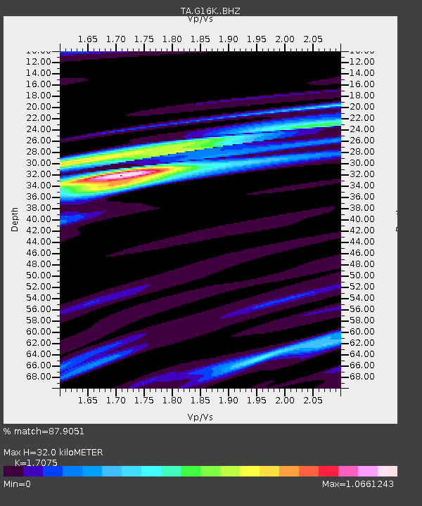
| Estimated Moho Depth: |
32.0 km |
| Estimated Crust Vp/Vs: |
1.71 |
| Assumed Crust Vp: |
6.276 km/s |
| Estimated Crust Vs: |
3.675 km/s |
| Estimated Crust Poisson's Ratio: |
0.24 |
|
| Radial Match: |
87.9051 % |
| Radial Bump: |
371 |
| Transverse Match: |
57.624287 % |
| Transverse Bump: |
400 |
| SOD ConfigId: |
23341671 |
| Insert Time: |
2021-03-04 07:50:58.081 +0000 |
| GWidth: |
2.5 |
| Max Bumps: |
400 |
| Tol: |
0.001 |
|
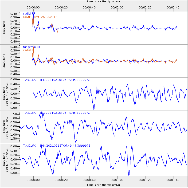
Signal To Noise
| Channel | StoN | STA | LTA |
| TA:G16K: :BHZ:20210218T06:49:45.399997Z | 6.1882343 | 7.309612E-7 | 1.18121115E-7 |
| TA:G16K: :BHN:20210218T06:49:45.399997Z | 2.1002817 | 1.9992508E-7 | 9.5189655E-8 |
| TA:G16K: :BHE:20210218T06:49:45.399997Z | 2.1324346 | 2.0060871E-7 | 9.407496E-8 |
| Arrivals |
| Ps | 3.7 SECOND |
| PpPs | 13 SECOND |
| PsPs/PpSs | 17 SECOND |


