You are here: Home > Network List > TA - USArray Transportable Network (new EarthScope stations) Stations List
> Station M15K Kasigluk River, AK, USA > Earthquake Result Viewer
M15K Kasigluk River, AK, USA - Earthquake Result Viewer
| Earthquake location: |
Vanuatu Islands Region |
| Earthquake latitude/longitude: |
-19.0/167.9 |
| Earthquake time(UTC): |
2021/02/18 (049) 06:37:30 GMT |
| Earthquake Depth: |
10 km |
| Earthquake Magnitude: |
6.2 mww |
| Earthquake Catalog/Contributor: |
NEIC PDE/us |
|
| Network: |
TA USArray Transportable Network (new EarthScope stations) |
| Station: |
M15K Kasigluk River, AK, USA |
| Lat/Lon: |
60.69 N/160.69 W |
| Elevation: |
210 m |
|
| Distance: |
83.4 deg |
| Az: |
14.964 deg |
| Baz: |
209.774 deg |
| Ray Param: |
0.046235036 |
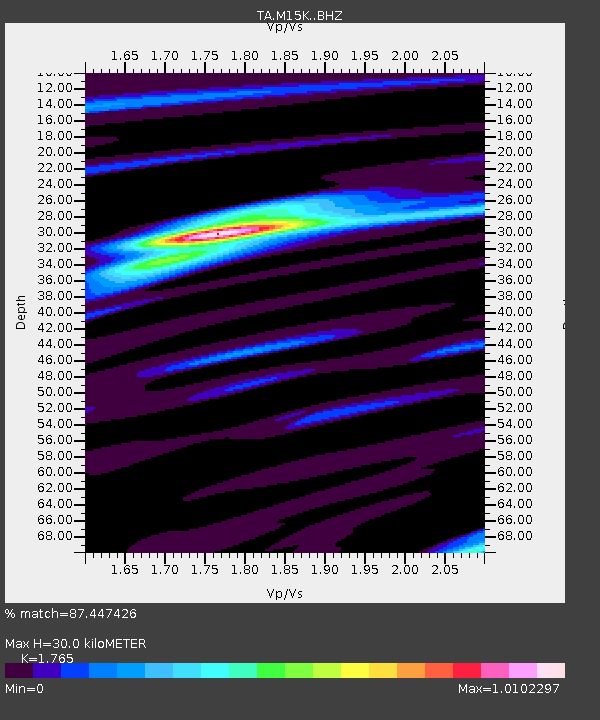
| Estimated Moho Depth: |
30.0 km |
| Estimated Crust Vp/Vs: |
1.76 |
| Assumed Crust Vp: |
6.182 km/s |
| Estimated Crust Vs: |
3.503 km/s |
| Estimated Crust Poisson's Ratio: |
0.26 |
|
| Radial Match: |
87.447426 % |
| Radial Bump: |
375 |
| Transverse Match: |
53.72388 % |
| Transverse Bump: |
400 |
| SOD ConfigId: |
23341671 |
| Insert Time: |
2021-03-04 07:51:26.780 +0000 |
| GWidth: |
2.5 |
| Max Bumps: |
400 |
| Tol: |
0.001 |
|

Signal To Noise
| Channel | StoN | STA | LTA |
| TA:M15K: :BHZ:20210218T06:49:26.649997Z | 5.0615754 | 1.0158176E-6 | 2.0069197E-7 |
| TA:M15K: :BHN:20210218T06:49:26.649997Z | 1.898317 | 3.151981E-7 | 1.6604082E-7 |
| TA:M15K: :BHE:20210218T06:49:26.649997Z | 1.4599844 | 3.6255796E-7 | 2.4833002E-7 |
| Arrivals |
| Ps | 3.8 SECOND |
| PpPs | 13 SECOND |
| PsPs/PpSs | 17 SECOND |


