You are here: Home > Network List > TA - USArray Transportable Network (new EarthScope stations) Stations List
> Station O17K Koliganek, Bristol Bay, AK, USA > Earthquake Result Viewer
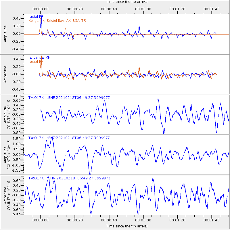
O17K Koliganek, Bristol Bay, AK, USA - Earthquake Result Viewer
*The percent match for this event was below the threshold and hence no stack was calculated.
| Earthquake location: |
Vanuatu Islands Region |
| Earthquake latitude/longitude: |
-19.0/167.9 |
| Earthquake time(UTC): |
2021/02/18 (049) 06:37:30 GMT |
| Earthquake Depth: |
10 km |
| Earthquake Magnitude: |
6.2 mww |
| Earthquake Catalog/Contributor: |
NEIC PDE/us |
|
| Network: |
TA USArray Transportable Network (new EarthScope stations) |
| Station: |
O17K Koliganek, Bristol Bay, AK, USA |
| Lat/Lon: |
59.77 N/157.09 W |
| Elevation: |
156 m |
|
| Distance: |
83.5 deg |
| Az: |
16.989 deg |
| Baz: |
213.12 deg |
| Ray Param: |
$rayparam |
*The percent match for this event was below the threshold and hence was not used in the summary stack. |
|
| Radial Match: |
72.88488 % |
| Radial Bump: |
359 |
| Transverse Match: |
57.529953 % |
| Transverse Bump: |
400 |
| SOD ConfigId: |
23341671 |
| Insert Time: |
2021-03-04 07:51:40.933 +0000 |
| GWidth: |
2.5 |
| Max Bumps: |
400 |
| Tol: |
0.001 |
|
Signal To Noise
| Channel | StoN | STA | LTA |
| TA:O17K: :BHZ:20210218T06:49:27.399997Z | 6.095577 | 9.183611E-7 | 1.5066024E-7 |
| TA:O17K: :BHN:20210218T06:49:27.399997Z | 2.051133 | 4.381237E-7 | 2.1360081E-7 |
| TA:O17K: :BHE:20210218T06:49:27.399997Z | 1.8363703 | 2.4833489E-7 | 1.3523137E-7 |
| Arrivals |
| Ps | |
| PpPs | |
| PsPs/PpSs | |


