You are here: Home > Network List > AK - Alaska Regional Network Stations List
> Station CUT Chulitna, AK, USA > Earthquake Result Viewer
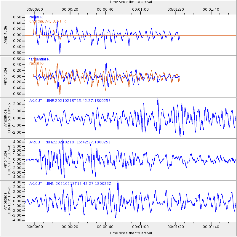
CUT Chulitna, AK, USA - Earthquake Result Viewer

| Earthquake location: |
Fiji Islands Region |
| Earthquake latitude/longitude: |
-14.9/-176.7 |
| Earthquake time(UTC): |
2021/02/18 (049) 15:30:50 GMT |
| Earthquake Depth: |
10 km |
| Earthquake Magnitude: |
6.1 mww |
| Earthquake Catalog/Contributor: |
NEIC PDE/us |
|
| Network: |
AK Alaska Regional Network |
| Station: |
CUT Chulitna, AK, USA |
| Lat/Lon: |
62.41 N/150.26 W |
| Elevation: |
574 m |
|
| Distance: |
79.8 deg |
| Az: |
12.178 deg |
| Baz: |
205.979 deg |
| Ray Param: |
0.048718803 |
| Estimated Moho Depth: |
52.75 km |
| Estimated Crust Vp/Vs: |
2.01 |
| Assumed Crust Vp: |
6.438 km/s |
| Estimated Crust Vs: |
3.203 km/s |
| Estimated Crust Poisson's Ratio: |
0.34 |
|
| Radial Match: |
83.83274 % |
| Radial Bump: |
400 |
| Transverse Match: |
66.67601 % |
| Transverse Bump: |
400 |
| SOD ConfigId: |
23341671 |
| Insert Time: |
2021-03-04 16:32:38.585 +0000 |
| GWidth: |
2.5 |
| Max Bumps: |
400 |
| Tol: |
0.001 |
|
Signal To Noise
| Channel | StoN | STA | LTA |
| AK:CUT: :BHZ:20210218T15:42:27.180025Z | 4.413956 | 1.0025182E-6 | 2.2712463E-7 |
| AK:CUT: :BHN:20210218T15:42:27.180025Z | 1.5819495 | 6.224385E-7 | 3.9346295E-7 |
| AK:CUT: :BHE:20210218T15:42:27.180025Z | 1.3827517 | 6.981312E-7 | 5.048854E-7 |
| Arrivals |
| Ps | 8.5 SECOND |
| PpPs | 24 SECOND |
| PsPs/PpSs | 33 SECOND |


