You are here: Home > Network List > GE - GEOFON Stations List
> Station SNAA AWI/GEOFON Station Sanae, Antarctica > Earthquake Result Viewer
SNAA AWI/GEOFON Station Sanae, Antarctica - Earthquake Result Viewer
| Earthquake location: |
Southeast Of Loyalty Islands |
| Earthquake latitude/longitude: |
-22.3/170.9 |
| Earthquake time(UTC): |
1998/01/04 (004) 06:11:58 GMT |
| Earthquake Depth: |
101 km |
| Earthquake Magnitude: |
6.4 MB, 7.4 UNKNOWN, 7.3 ME |
| Earthquake Catalog/Contributor: |
WHDF/NEIC |
|
| Network: |
GE GEOFON |
| Station: |
SNAA AWI/GEOFON Station Sanae, Antarctica |
| Lat/Lon: |
71.67 S/2.84 W |
| Elevation: |
846 m |
|
| Distance: |
86.2 deg |
| Az: |
181.979 deg |
| Baz: |
174.2 deg |
| Ray Param: |
0.04402735 |
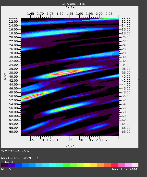
| Estimated Moho Depth: |
37.75 km |
| Estimated Crust Vp/Vs: |
1.82 |
| Assumed Crust Vp: |
6.43 km/s |
| Estimated Crust Vs: |
3.533 km/s |
| Estimated Crust Poisson's Ratio: |
0.28 |
|
| Radial Match: |
97.75873 % |
| Radial Bump: |
400 |
| Transverse Match: |
89.65866 % |
| Transverse Bump: |
400 |
| SOD ConfigId: |
4480 |
| Insert Time: |
2010-03-09 05:40:08.332 +0000 |
| GWidth: |
2.5 |
| Max Bumps: |
400 |
| Tol: |
0.001 |
|

Signal To Noise
| Channel | StoN | STA | LTA |
| GE:SNAA: :BHN:19980104T06:23:57.777014Z | 21.461996 | 3.2065418E-6 | 1.4940558E-7 |
| GE:SNAA: :BHE:19980104T06:23:57.777014Z | 9.7792225 | 1.126676E-6 | 1.1521121E-7 |
| GE:SNAA: :BHZ:19980104T06:23:57.777014Z | 2.2772603 | 3.3423646E-7 | 1.467713E-7 |
| Arrivals |
| Ps | 4.9 SECOND |
| PpPs | 16 SECOND |
| PsPs/PpSs | 21 SECOND |


