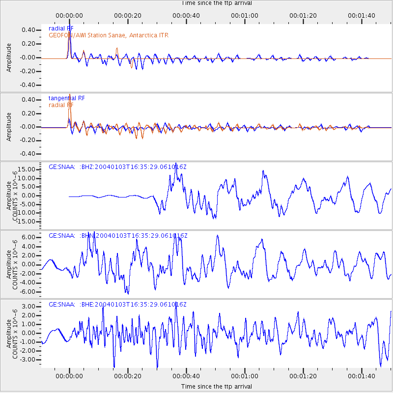
SNAA GEOFON/AWI Station Sanae, Antarctica - Earthquake Result Viewer
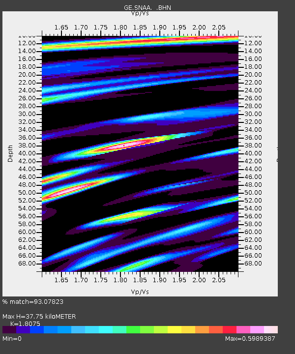
Earthquake location: Southeast Of Loyalty Islands
Earthquake latitude/longitude: -22.3/169.7
Earthquake time(UTC): 2004/01/03 (003) 16:23:21 GMT
Earthquake Depth: 22 km
Earthquake Magnitude: 6.4 MB, 7.1 MS, 7.1 MW, 6.8 MW
Earthquake Catalog/Contributor: WHDF/NEIC
Network: GE GEOFON
Station: SNAA GEOFON/AWI Station Sanae, Antarctica
Lat/Lon: 71.67 S/2.84 W
Elevation: 846 m
Distance: 86.2 deg
Az: 182.365 deg
Baz: 173.059 deg
Ray Param: 0.044212162
Estimated Moho Depth: 37.75 km
Estimated Crust Vp/Vs: 1.81
Assumed Crust Vp: 6.43 km/s
Estimated Crust Vs: 3.557 km/s
Estimated Crust Poisson's Ratio: 0.28
Radial Match: 93.07823 %
Radial Bump: 400
Transverse Match: 69.316925 %
Transverse Bump: 400
SOD ConfigId: 7314
Insert Time: 2010-03-09 05:40:27.837 +0000
GWidth: 2.5
Max Bumps: 400
Tol: 0.001

Signal To Noise

ChannelStoNSTALTA
GE:SNAA: :BHN:20040103T16:35:29.061016Z2.5240011.8068904E-67.158834E-7
GE:SNAA: :BHE:20040103T16:35:29.061016Z0.780703966.5452303E-78.383754E-7
GE:SNAA: :BHZ:20040103T16:35:29.061016Z15.1020666.006918E-63.977547E-7
Arrivals
Ps4.9 SECOND
PpPs16 SECOND
PsPs/PpSs21 SECOND