You are here: Home > Network List > GE - GEOFON Stations List
> Station SNAA GEOFON/AWI Station Sanae, Antarctica > Earthquake Result Viewer
SNAA GEOFON/AWI Station Sanae, Antarctica - Earthquake Result Viewer
| Earthquake location: |
Timor Region |
| Earthquake latitude/longitude: |
-8.2/124.9 |
| Earthquake time(UTC): |
2004/11/11 (316) 21:26:41 GMT |
| Earthquake Depth: |
10 km |
| Earthquake Magnitude: |
6.5 MB, 7.3 MS, 7.5 MW, 7.4 MW |
| Earthquake Catalog/Contributor: |
WHDF/NEIC |
|
| Network: |
GE GEOFON |
| Station: |
SNAA GEOFON/AWI Station Sanae, Antarctica |
| Lat/Lon: |
71.67 S/2.84 W |
| Elevation: |
846 m |
|
| Distance: |
93.3 deg |
| Az: |
194.521 deg |
| Baz: |
128.317 deg |
| Ray Param: |
0.041283727 |
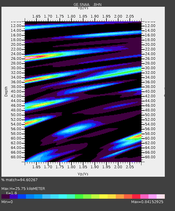
| Estimated Moho Depth: |
25.75 km |
| Estimated Crust Vp/Vs: |
1.60 |
| Assumed Crust Vp: |
6.43 km/s |
| Estimated Crust Vs: |
4.019 km/s |
| Estimated Crust Poisson's Ratio: |
0.18 |
|
| Radial Match: |
94.60267 % |
| Radial Bump: |
400 |
| Transverse Match: |
86.42144 % |
| Transverse Bump: |
400 |
| SOD ConfigId: |
2459 |
| Insert Time: |
2010-03-09 05:40:33.736 +0000 |
| GWidth: |
2.5 |
| Max Bumps: |
400 |
| Tol: |
0.001 |
|

Signal To Noise
| Channel | StoN | STA | LTA |
| GE:SNAA: :BHN:20041111T21:39:24.493994Z | 2.2922037 | 1.7561274E-7 | 7.661306E-8 |
| GE:SNAA: :BHE:20041111T21:39:24.493994Z | 3.397764 | 2.097786E-7 | 6.174019E-8 |
| GE:SNAA: :BHZ:20041111T21:39:24.493994Z | 10.612449 | 1.0056107E-6 | 9.475765E-8 |
| Arrivals |
| Ps | 2.5 SECOND |
| PpPs | 10 SECOND |
| PsPs/PpSs | 13 SECOND |


