You are here: Home > Network List > TA - USArray Transportable Network (new EarthScope stations) Stations List
> Station D23K Nanushuk River, AK USA > Earthquake Result Viewer
D23K Nanushuk River, AK USA - Earthquake Result Viewer
| Earthquake location: |
Fiji Islands Region |
| Earthquake latitude/longitude: |
-14.9/-176.7 |
| Earthquake time(UTC): |
2021/02/18 (049) 15:30:50 GMT |
| Earthquake Depth: |
10 km |
| Earthquake Magnitude: |
6.1 mww |
| Earthquake Catalog/Contributor: |
NEIC PDE/us |
|
| Network: |
TA USArray Transportable Network (new EarthScope stations) |
| Station: |
D23K Nanushuk River, AK USA |
| Lat/Lon: |
68.97 N/150.68 W |
| Elevation: |
406 m |
|
| Distance: |
85.7 deg |
| Az: |
9.153 deg |
| Baz: |
205.214 deg |
| Ray Param: |
0.044605315 |
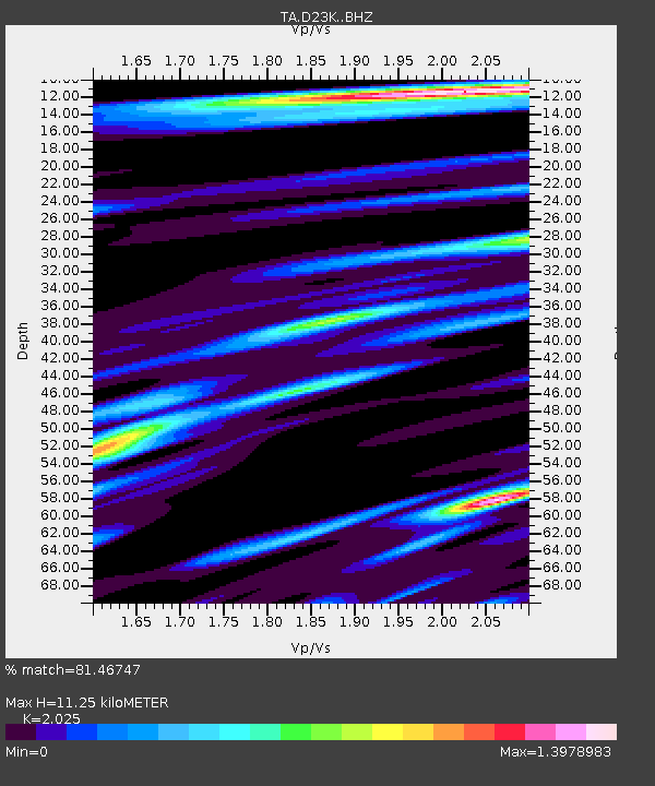
| Estimated Moho Depth: |
11.25 km |
| Estimated Crust Vp/Vs: |
2.03 |
| Assumed Crust Vp: |
6.221 km/s |
| Estimated Crust Vs: |
3.072 km/s |
| Estimated Crust Poisson's Ratio: |
0.34 |
|
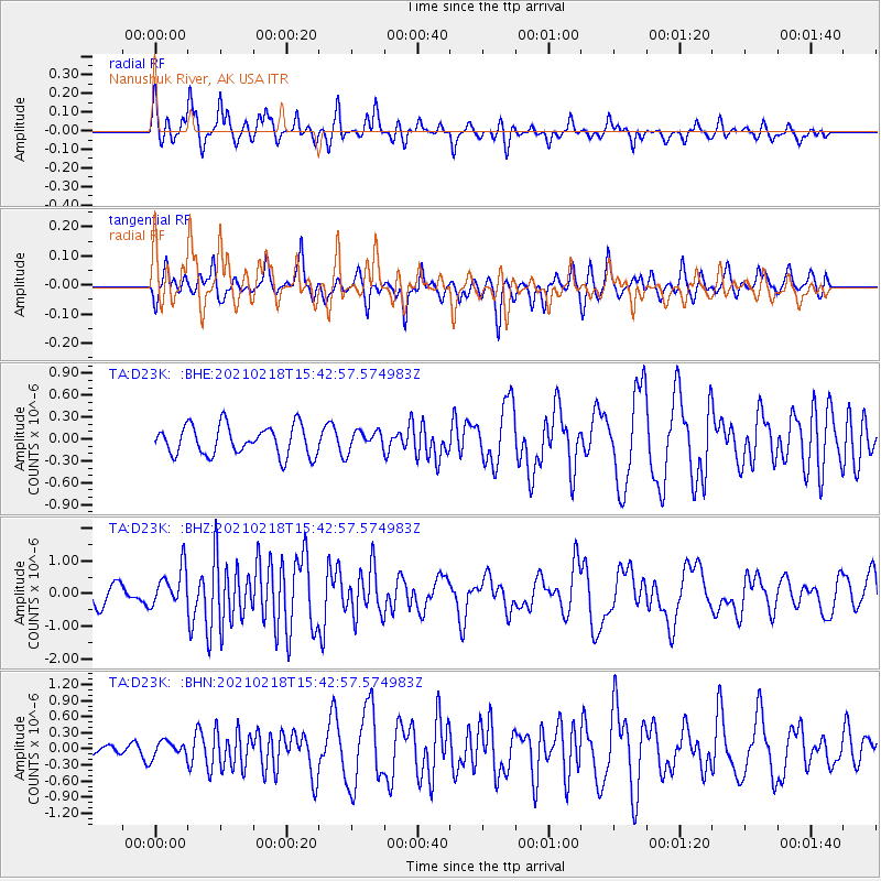
| Radial Match: |
81.46747 % |
| Radial Bump: |
365 |
| Transverse Match: |
60.426594 % |
| Transverse Bump: |
315 |
| SOD ConfigId: |
23341671 |
| Insert Time: |
2021-03-04 16:47:18.929 +0000 |
| GWidth: |
2.5 |
| Max Bumps: |
400 |
| Tol: |
0.001 |
|
Signal To Noise
| Channel | StoN | STA | LTA |
| TA:D23K: :BHZ:20210218T15:42:57.574983Z | 1.9154768 | 5.84361E-7 | 3.0507337E-7 |
| TA:D23K: :BHN:20210218T15:42:57.574983Z | 0.8771427 | 1.4855006E-7 | 1.6935677E-7 |
| TA:D23K: :BHE:20210218T15:42:57.574983Z | 0.66501033 | 1.3410242E-7 | 2.0165463E-7 |
| Arrivals |
| Ps | 1.9 SECOND |
| PpPs | 5.4 SECOND |
| PsPs/PpSs | 7.3 SECOND |


