You are here: Home > Network List > TA - USArray Transportable Network (new EarthScope stations) Stations List
> Station F14K Arctic Creek, AK, USA > Earthquake Result Viewer
F14K Arctic Creek, AK, USA - Earthquake Result Viewer
| Earthquake location: |
Fiji Islands Region |
| Earthquake latitude/longitude: |
-14.9/-176.7 |
| Earthquake time(UTC): |
2021/02/18 (049) 15:30:50 GMT |
| Earthquake Depth: |
10 km |
| Earthquake Magnitude: |
6.1 mww |
| Earthquake Catalog/Contributor: |
NEIC PDE/us |
|
| Network: |
TA USArray Transportable Network (new EarthScope stations) |
| Station: |
F14K Arctic Creek, AK, USA |
| Lat/Lon: |
65.47 N/166.33 W |
| Elevation: |
266 m |
|
| Distance: |
80.5 deg |
| Az: |
4.387 deg |
| Baz: |
190.206 deg |
| Ray Param: |
0.048236445 |
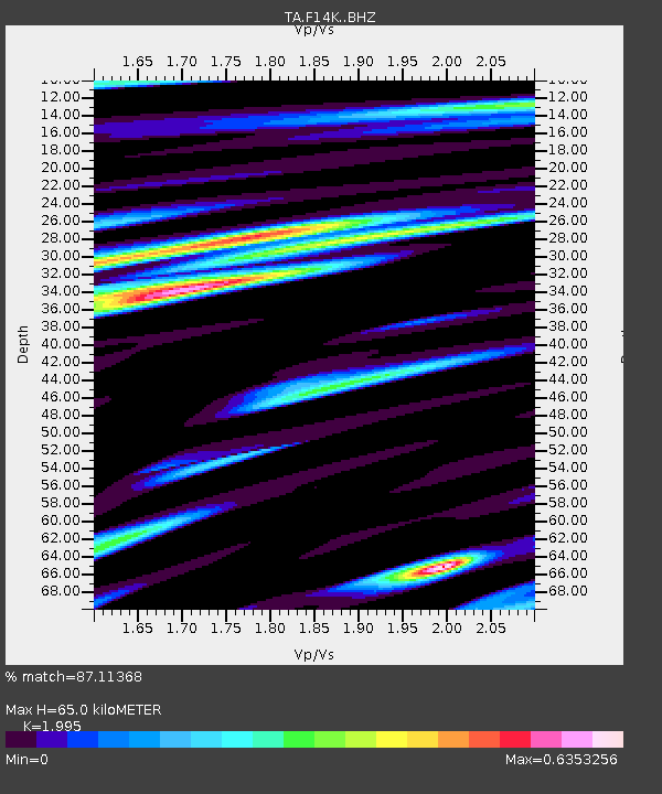
| Estimated Moho Depth: |
65.0 km |
| Estimated Crust Vp/Vs: |
2.00 |
| Assumed Crust Vp: |
6.307 km/s |
| Estimated Crust Vs: |
3.161 km/s |
| Estimated Crust Poisson's Ratio: |
0.33 |
|
| Radial Match: |
87.11368 % |
| Radial Bump: |
400 |
| Transverse Match: |
73.06777 % |
| Transverse Bump: |
400 |
| SOD ConfigId: |
23341671 |
| Insert Time: |
2021-03-04 16:47:26.432 +0000 |
| GWidth: |
2.5 |
| Max Bumps: |
400 |
| Tol: |
0.001 |
|

Signal To Noise
| Channel | StoN | STA | LTA |
| TA:F14K: :BHZ:20210218T15:42:30.975008Z | 4.0628037 | 6.667572E-7 | 1.6411259E-7 |
| TA:F14K: :BHN:20210218T15:42:30.975008Z | 2.2262642 | 2.1132992E-7 | 9.49258E-8 |
| TA:F14K: :BHE:20210218T15:42:30.975008Z | 1.2398978 | 1.2981512E-7 | 1.0469824E-7 |
| Arrivals |
| Ps | 11 SECOND |
| PpPs | 30 SECOND |
| PsPs/PpSs | 41 SECOND |


