You are here: Home > Network List > TA - USArray Transportable Network (new EarthScope stations) Stations List
> Station F26K Sheenjek River, AK, USA > Earthquake Result Viewer
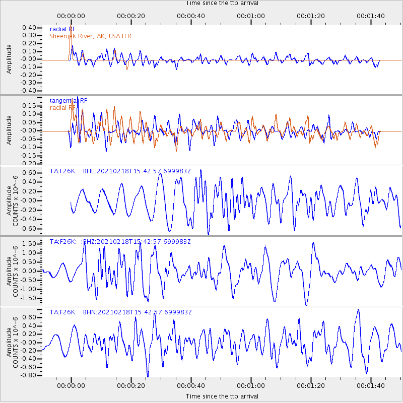
F26K Sheenjek River, AK, USA - Earthquake Result Viewer
*The percent match for this event was below the threshold and hence no stack was calculated.
| Earthquake location: |
Fiji Islands Region |
| Earthquake latitude/longitude: |
-14.9/-176.7 |
| Earthquake time(UTC): |
2021/02/18 (049) 15:30:50 GMT |
| Earthquake Depth: |
10 km |
| Earthquake Magnitude: |
6.1 mww |
| Earthquake Catalog/Contributor: |
NEIC PDE/us |
|
| Network: |
TA USArray Transportable Network (new EarthScope stations) |
| Station: |
F26K Sheenjek River, AK, USA |
| Lat/Lon: |
67.69 N/144.15 W |
| Elevation: |
683 m |
|
| Distance: |
85.7 deg |
| Az: |
11.901 deg |
| Baz: |
211.49 deg |
| Ray Param: |
$rayparam |
*The percent match for this event was below the threshold and hence was not used in the summary stack. |
|
| Radial Match: |
66.59783 % |
| Radial Bump: |
400 |
| Transverse Match: |
59.743557 % |
| Transverse Bump: |
400 |
| SOD ConfigId: |
23341671 |
| Insert Time: |
2021-03-04 16:47:32.933 +0000 |
| GWidth: |
2.5 |
| Max Bumps: |
400 |
| Tol: |
0.001 |
|
Signal To Noise
| Channel | StoN | STA | LTA |
| TA:F26K: :BHZ:20210218T15:42:57.699983Z | 3.9869363 | 6.653739E-7 | 1.6688851E-7 |
| TA:F26K: :BHN:20210218T15:42:57.699983Z | 1.7416673 | 2.5298698E-7 | 1.4525564E-7 |
| TA:F26K: :BHE:20210218T15:42:57.699983Z | 2.328441 | 4.5377863E-7 | 1.9488517E-7 |
| Arrivals |
| Ps | |
| PpPs | |
| PsPs/PpSs | |


