You are here: Home > Network List > US - United States National Seismic Network Stations List
> Station DGMT Dagmar, Montana, USA > Earthquake Result Viewer
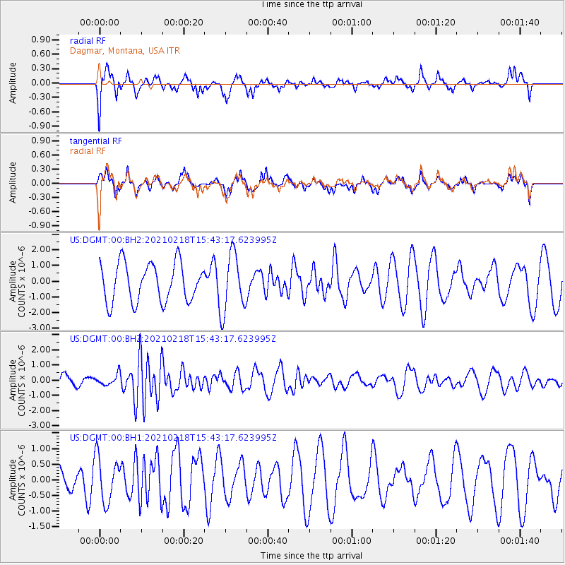
DGMT Dagmar, Montana, USA - Earthquake Result Viewer
*The percent match for this event was below the threshold and hence no stack was calculated.
| Earthquake location: |
Fiji Islands Region |
| Earthquake latitude/longitude: |
-14.9/-176.7 |
| Earthquake time(UTC): |
2021/02/18 (049) 15:30:50 GMT |
| Earthquake Depth: |
10 km |
| Earthquake Magnitude: |
6.1 mww |
| Earthquake Catalog/Contributor: |
NEIC PDE/us |
|
| Network: |
US United States National Seismic Network |
| Station: |
DGMT Dagmar, Montana, USA |
| Lat/Lon: |
48.47 N/104.20 W |
| Elevation: |
0.0 m |
|
| Distance: |
89.9 deg |
| Az: |
39.41 deg |
| Baz: |
247.277 deg |
| Ray Param: |
$rayparam |
*The percent match for this event was below the threshold and hence was not used in the summary stack. |
|
| Radial Match: |
64.547775 % |
| Radial Bump: |
356 |
| Transverse Match: |
55.646214 % |
| Transverse Bump: |
359 |
| SOD ConfigId: |
23341671 |
| Insert Time: |
2021-03-04 16:50:17.757 +0000 |
| GWidth: |
2.5 |
| Max Bumps: |
400 |
| Tol: |
0.001 |
|
Signal To Noise
| Channel | StoN | STA | LTA |
| US:DGMT:00:BHZ:20210218T15:43:17.623995Z | 1.1983047 | 3.6917925E-7 | 3.0808462E-7 |
| US:DGMT:00:BH1:20210218T15:43:17.623995Z | 1.1413456 | 7.2497807E-7 | 6.3519593E-7 |
| US:DGMT:00:BH2:20210218T15:43:17.623995Z | 1.5038435 | 1.8340664E-6 | 1.219586E-6 |
| Arrivals |
| Ps | |
| PpPs | |
| PsPs/PpSs | |


