You are here: Home > Network List > US - United States National Seismic Network Stations List
> Station AMTX Amarillo, Texas, USA > Earthquake Result Viewer
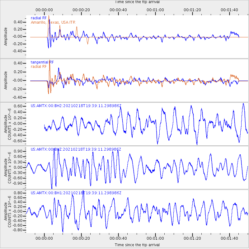
AMTX Amarillo, Texas, USA - Earthquake Result Viewer
*The percent match for this event was below the threshold and hence no stack was calculated.
| Earthquake location: |
Central East Pacific Rise |
| Earthquake latitude/longitude: |
-9.1/-108.2 |
| Earthquake time(UTC): |
2021/02/18 (049) 19:31:33 GMT |
| Earthquake Depth: |
10 km |
| Earthquake Magnitude: |
5.8 Mww |
| Earthquake Catalog/Contributor: |
NEIC PDE/us |
|
| Network: |
US United States National Seismic Network |
| Station: |
AMTX Amarillo, Texas, USA |
| Lat/Lon: |
34.53 N/101.41 W |
| Elevation: |
1010 m |
|
| Distance: |
43.9 deg |
| Az: |
8.081 deg |
| Baz: |
189.68 deg |
| Ray Param: |
$rayparam |
*The percent match for this event was below the threshold and hence was not used in the summary stack. |
|
| Radial Match: |
50.787632 % |
| Radial Bump: |
400 |
| Transverse Match: |
46.529873 % |
| Transverse Bump: |
400 |
| SOD ConfigId: |
23341671 |
| Insert Time: |
2021-03-04 20:58:13.077 +0000 |
| GWidth: |
2.5 |
| Max Bumps: |
400 |
| Tol: |
0.001 |
|
Signal To Noise
| Channel | StoN | STA | LTA |
| US:AMTX:00:BHZ:20210218T19:39:11.298986Z | 2.2951183 | 4.1049174E-7 | 1.7885428E-7 |
| US:AMTX:00:BH1:20210218T19:39:11.298986Z | 1.2917045 | 2.3998584E-7 | 1.8579004E-7 |
| US:AMTX:00:BH2:20210218T19:39:11.298986Z | 1.084033 | 1.641115E-7 | 1.5138974E-7 |
| Arrivals |
| Ps | |
| PpPs | |
| PsPs/PpSs | |


