You are here: Home > Network List > US - United States National Seismic Network Stations List
> Station DGMT Dagmar, Montana, USA > Earthquake Result Viewer
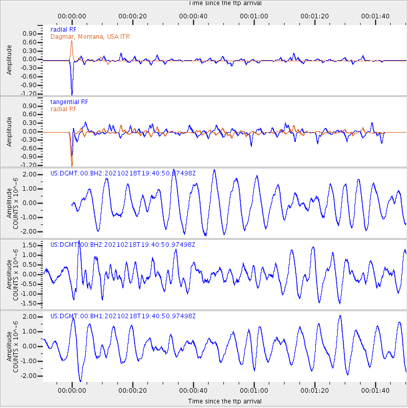
DGMT Dagmar, Montana, USA - Earthquake Result Viewer
*The percent match for this event was below the threshold and hence no stack was calculated.
| Earthquake location: |
Central East Pacific Rise |
| Earthquake latitude/longitude: |
-9.1/-108.2 |
| Earthquake time(UTC): |
2021/02/18 (049) 19:31:33 GMT |
| Earthquake Depth: |
10 km |
| Earthquake Magnitude: |
5.8 Mww |
| Earthquake Catalog/Contributor: |
NEIC PDE/us |
|
| Network: |
US United States National Seismic Network |
| Station: |
DGMT Dagmar, Montana, USA |
| Lat/Lon: |
48.47 N/104.20 W |
| Elevation: |
0.0 m |
|
| Distance: |
57.4 deg |
| Az: |
3.15 deg |
| Baz: |
184.677 deg |
| Ray Param: |
$rayparam |
*The percent match for this event was below the threshold and hence was not used in the summary stack. |
|
| Radial Match: |
66.930466 % |
| Radial Bump: |
189 |
| Transverse Match: |
34.899334 % |
| Transverse Bump: |
321 |
| SOD ConfigId: |
23341671 |
| Insert Time: |
2021-03-04 20:58:21.174 +0000 |
| GWidth: |
2.5 |
| Max Bumps: |
400 |
| Tol: |
0.001 |
|
Signal To Noise
| Channel | StoN | STA | LTA |
| US:DGMT:00:BHZ:20210218T19:40:50.97498Z | 3.5250843 | 8.299447E-7 | 2.3543969E-7 |
| US:DGMT:00:BH1:20210218T19:40:50.97498Z | 2.270684 | 1.4292001E-6 | 6.2941393E-7 |
| US:DGMT:00:BH2:20210218T19:40:50.97498Z | 1.7224913 | 1.441305E-6 | 8.3675604E-7 |
| Arrivals |
| Ps | |
| PpPs | |
| PsPs/PpSs | |


