You are here: Home > Network List > GS - US Geological Survey Networks Stations List
> Station ASL8 Albuquerque, New Mexico, USA > Earthquake Result Viewer
ASL8 Albuquerque, New Mexico, USA - Earthquake Result Viewer

| Earthquake location: |
Tonga Islands |
| Earthquake latitude/longitude: |
-20.6/-173.9 |
| Earthquake time(UTC): |
2017/10/18 (291) 12:00:59 GMT |
| Earthquake Depth: |
10 km |
| Earthquake Magnitude: |
6.0 Mww |
| Earthquake Catalog/Contributor: |
NEIC PDE/us |
|
| Network: |
GS US Geological Survey Networks |
| Station: |
ASL8 Albuquerque, New Mexico, USA |
| Lat/Lon: |
34.95 N/106.46 W |
| Elevation: |
1820 m |
|
| Distance: |
84.5 deg |
| Az: |
49.652 deg |
| Baz: |
240.359 deg |
| Ray Param: |
0.045439206 |
| Estimated Moho Depth: |
12.0 km |
| Estimated Crust Vp/Vs: |
1.63 |
| Assumed Crust Vp: |
6.502 km/s |
| Estimated Crust Vs: |
3.983 km/s |
| Estimated Crust Poisson's Ratio: |
0.20 |
|
| Radial Match: |
95.34767 % |
| Radial Bump: |
371 |
| Transverse Match: |
88.42478 % |
| Transverse Bump: |
355 |
| SOD ConfigId: |
2364251 |
| Insert Time: |
2017-11-01 12:04:07.324 +0000 |
| GWidth: |
2.5 |
| Max Bumps: |
400 |
| Tol: |
0.001 |
|
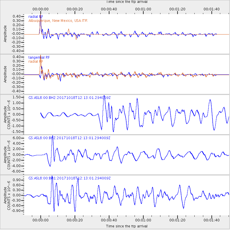
Signal To Noise
| Channel | StoN | STA | LTA |
| GS:ASL8:00:BHZ:20171018T12:13:01.294009Z | 4.416926 | 8.5602176E-7 | 1.9380487E-7 |
| GS:ASL8:00:BH1:20171018T12:13:01.294009Z | 1.3860198 | 1.7338074E-7 | 1.2509254E-7 |
| GS:ASL8:00:BH2:20171018T12:13:01.294009Z | 1.5014871 | 1.7282922E-7 | 1.1510536E-7 |
| Arrivals |
| Ps | 1.2 SECOND |
| PpPs | 4.7 SECOND |
| PsPs/PpSs | 5.9 SECOND |


