You are here: Home > Network List > GS - US Geological Survey Networks Stations List
> Station ID06 Fossil Canyon, Idaho, USA > Earthquake Result Viewer
ID06 Fossil Canyon, Idaho, USA - Earthquake Result Viewer
| Earthquake location: |
Tonga Islands |
| Earthquake latitude/longitude: |
-20.6/-173.9 |
| Earthquake time(UTC): |
2017/10/18 (291) 12:00:59 GMT |
| Earthquake Depth: |
10 km |
| Earthquake Magnitude: |
6.0 Mww |
| Earthquake Catalog/Contributor: |
NEIC PDE/us |
|
| Network: |
GS US Geological Survey Networks |
| Station: |
ID06 Fossil Canyon, Idaho, USA |
| Lat/Lon: |
42.59 N/111.45 W |
| Elevation: |
1897 m |
|
| Distance: |
85.2 deg |
| Az: |
41.078 deg |
| Baz: |
236.463 deg |
| Ray Param: |
0.044960372 |
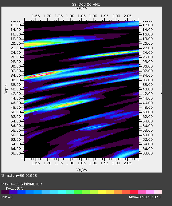
| Estimated Moho Depth: |
33.5 km |
| Estimated Crust Vp/Vs: |
1.67 |
| Assumed Crust Vp: |
6.207 km/s |
| Estimated Crust Vs: |
3.722 km/s |
| Estimated Crust Poisson's Ratio: |
0.22 |
|
| Radial Match: |
89.91928 % |
| Radial Bump: |
400 |
| Transverse Match: |
87.31739 % |
| Transverse Bump: |
400 |
| SOD ConfigId: |
2364251 |
| Insert Time: |
2017-11-01 12:04:28.166 +0000 |
| GWidth: |
2.5 |
| Max Bumps: |
400 |
| Tol: |
0.001 |
|

Signal To Noise
| Channel | StoN | STA | LTA |
| GS:ID06:00:HHZ:20171018T12:13:04.624026Z | 7.7585225 | 1.2530091E-6 | 1.6150099E-7 |
| GS:ID06:00:HH1:20171018T12:13:04.624026Z | 1.9415209 | 3.1841785E-7 | 1.6400433E-7 |
| GS:ID06:00:HH2:20171018T12:13:04.624026Z | 3.263685 | 4.3958724E-7 | 1.3469047E-7 |
| Arrivals |
| Ps | 3.7 SECOND |
| PpPs | 14 SECOND |
| PsPs/PpSs | 18 SECOND |


